Soweto geodata
Soweto (Gauteng) is a populated place; located in South Africa in Africa/Johannesburg (GMT+2) time zone. With population of 1,695,047 people, there are 3 cities with bigger population in this country. Compared to other cities in South Africa, 77% of cities are located further ↓South; 52.5% of cities are located further ←West and 93.2% of cities have lower elevation than Soweto. Note1
Administrative division(s):
- Level 1: Gauteng
- Level 2: City of Johannesburg Metropolitan Municipality
- Level 3: City of Johannesburg


Soweto GPS coordinates[2]
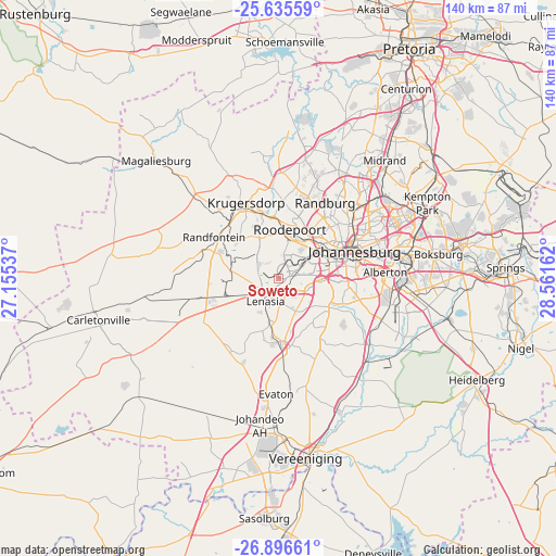
26° 16' 4.116" South, 27° 51' 30.564" East
| Map corner | latitude | longitude |
|---|---|---|
| Upper-left | -25.63559°, | 27.15537° |
| Center: | -26.26781°, | 27.85849° |
| Lower-right: | -26.89661°, | 28.56162° |
| Map W x H: | 140.2×140.2 km | = 87.1×87.1mi |
| max Lat: | -22.34881° ⇑23% North |
| Soweto: | -26.26781° |
| min Lat: | ⇓77% South -34.66739° |
| min Long | Soweto | max Long |
| 16.8697° | 27.85849° | 32.26762° |
| W 52.5%⇐ | ⇒47.5% E |
Elevation
Elevation of Soweto is 1632 m = 5354 ft, and this is 662.4 m = 2173 ft above average elevation for this country.
| Max E: |
1873 m = 6145 ft | 6.8% |
| Soweto | 1632 m 5354 ft | |
| Avg. | 969.6 m = 3181 ft | |
Min E: |
7 m = 23 ft | 93.2% |
See also: Soweto elevation on elevation.city.
Geographical zone
Soweto is located in South temperate zone (between Tropic of Capricorn and the Antarctic Circle). Distance of this Southern Tropic circle is 314.8 km =195.6 mi to North.| Distance of | km | miles | from Soweto |
|---|---|---|---|
| Equator | 2920.7 | 1814.8 | to North |
| Tropic Capricorn | 314.8 | 195.6 | to North |
| Antarctic Circle | 4480.5 | 2784.1 | to South |
| South Pole | 7086.4 | 4403.3 | to South |


Nearby cities:
15 places around Soweto: (largest is in red/bold)
• Alberton
26.3 km =16.3 mi,  90°
90°
• Eastleigh
33.4 km =20.8 mi,  62°
62°
• Eden Glen
34.4 km =21.4 mi, 64°
• Eden Glen Ext 60
34.4 km =21.4 mi, 62°
• Edenvale
32.5 km =20.2 mi, 64°
• Germiston
31.9 km =19.8 mi,  83°
83°
• Johannesburg
19.9 km =12.4 mi,  68°
68°
• Krugersdorp
21.9 km =13.6 mi,  337°
337°
• Muldersdriseloop
25.8 km =16 mi,  355°
355°
• Orange Farm
24 km =14.9 mi,  178°
178°
• Randburg
24 km =14.9 mi,  36°
36°
• Randfontein
18.2 km =11.3 mi,  300°
300°
• Riverlea
13 km =8.1 mi, 61°
• Roodepoort
11.8 km =7.3 mi,  6°
6°
• Westonaria
21.7 km =13.5 mi,  254°
254°
Sources, notices
• [Note1] Compared only with cities in South Africa existing in our database
• [Src1] Map data: © OpenStreetMap contributors (CC-BY-SA)
• [Src2] Other city data from geonames.org with taken over terms of usage.
• [Src3] Geographical zone / Annual Mean Temperature by Robert A. Rohde @ Wikipedia
