Randfontein geodata
Randfontein (Gauteng) is a seat of a second-order administrative division; located in South Africa in Africa/Johannesburg (GMT+2) time zone. With population of 133,654 people, there are 40 cities with bigger population in this country. Compared to other cities in South Africa, 79.4% of cities are located further ↓South; 50.1% of cities are located further ←West and 98.2% of cities have lower elevation than Randfontein. Note1
Administrative division(s):
- Level 1: Gauteng
- Level 2: West Rand District Municipality
- Level 3: Randfontein


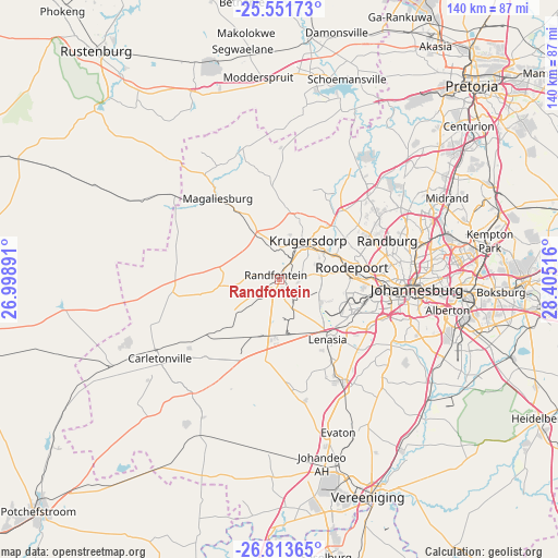
Randfontein GPS coordinates[2]
26° 11' 3.84" South, 27° 42' 7.308" East
| Map corner | latitude | longitude |
|---|---|---|
| Upper-left | -25.55173°, | 26.99891° |
| Center: | -26.1844°, | 27.70203° |
| Lower-right: | -26.81365°, | 28.40516° |
| Map W x H: | 140.3×140.3 km | = 87.2×87.2mi |
| max Lat: | -22.34881° ⇑20.6% North |
| Randfontein: | -26.1844° |
| min Lat: | ⇓79.4% South -34.66739° |
| min Long | Randfontein | max Long |
| 16.8697° | 27.70203° | 32.26762° |
| W 50.1%⇐ | ⇒49.9% E |
Elevation
Elevation of Randfontein is 1716 m = 5630 ft, and this is 746.4 m = 2449 ft above average elevation for this country.
| Max E: |
1873 m = 6145 ft | 1.8% |
| Randfontein | 1716 m 5630 ft | |
| Avg. | 969.6 m = 3181 ft | |
Min E: |
7 m = 23 ft | 98.2% |
See also: Randfontein elevation on elevation.city.
Geographical zone
Randfontein is located in South temperate zone (between Tropic of Capricorn and the Antarctic Circle). Distance of this Southern Tropic circle is 305.5 km =189.8 mi to North.| Distance of | km | miles | from Randfontein |
|---|---|---|---|
| Equator | 2911.4 | 1809.1 | to North |
| Tropic Capricorn | 305.5 | 189.8 | to North |
| Antarctic Circle | 4489.7 | 2789.8 | to South |
| South Pole | 7095.6 | 4409 | to South |


Nearby cities:
15 places around Randfontein: (largest is in red/bold)
• Alberton
42.9 km =26.7 mi,  102°
102°
• Carletonville
36.1 km =22.4 mi,  237°
237°
• Diepsloot
41.7 km =25.9 mi,  47°
47°
• Eastleigh
45.7 km =28.4 mi,  82°
82°
• Edenvale
45.2 km =28.1 mi, 83°
• Fochville
39.7 km =24.7 mi,  211°
211°
• Johannesburg
34.1 km =21.2 mi,  93°
93°
• Krugersdorp
13.2 km =8.2 mi,  33°
33°
• Muldersdriseloop
21.3 km =13.2 mi,  39°
39°
• Orange Farm
37.1 km =23.1 mi,  153°
153°
• Randburg
31.5 km =19.6 mi,  71°
71°
• Riverlea
27.2 km =16.9 mi, 96°
• Roodepoort
17.2 km =10.7 mi, 81°
• Soweto
18.2 km =11.3 mi,  120°
120°
• Westonaria
15.9 km =9.9 mi,  199°
199°
Sources, notices
• [Note1] Compared only with cities in South Africa existing in our database
• [Src1] Map data: © OpenStreetMap contributors (CC-BY-SA)
• [Src2] Other city data from geonames.org with taken over terms of usage.
• [Src3] Geographical zone / Annual Mean Temperature by Robert A. Rohde @ Wikipedia
