Johannesburg geodata
Johannesburg (Gauteng) is a seat of a first-order administrative division; located in South Africa in Africa/Johannesburg (GMT+2) time zone. With population of 2,026,469 people, there are 2 cities with bigger population in this country. Compared to other cities in South Africa, 78.8% of cities are located further ↓South; 56.6% of cities are located further ←West and 99.4% of cities have lower elevation than Johannesburg. Note1
Administrative division(s):
- Level 1: Gauteng
- Level 2: City of Johannesburg Metropolitan Municipality
- Level 3: City of Johannesburg


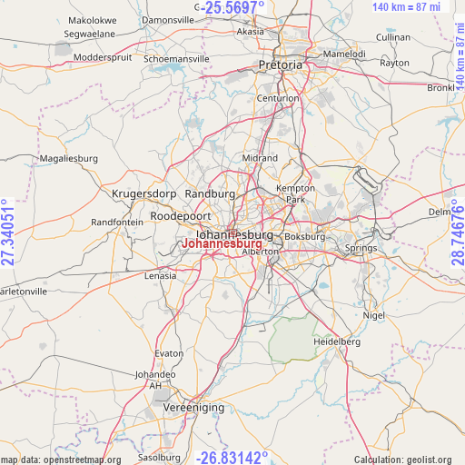
Johannesburg GPS coordinates[2]
26° 12' 8.172" South, 28° 2' 37.068" East
| Map corner | latitude | longitude |
|---|---|---|
| Upper-left | -25.5697°, | 27.34051° |
| Center: | -26.20227°, | 28.04363° |
| Lower-right: | -26.83142°, | 28.74676° |
| Map W x H: | 140.3×140.3 km | = 87.2×87.2mi |
| max Lat: | -22.34881° ⇑21.2% North |
| Johannesburg: | -26.20227° |
| min Lat: | ⇓78.8% South -34.66739° |
| min Long | Johannesburg | max Long |
| 16.8697° | 28.04363° | 32.26762° |
| W 56.6%⇐ | ⇒43.4% E |
Elevation
Elevation of Johannesburg is 1767 m = 5797 ft, and this is 797.4 m = 2616 ft above average elevation for this country.
| Max E: |
1873 m = 6145 ft | 0.59999999999999% |
| Johannesburg | 1767 m 5797 ft | |
| Avg. | 969.6 m = 3181 ft | |
Min E: |
7 m = 23 ft | 99.4% |
See also: Johannesburg elevation on elevation.city.
Geographical zone
Johannesburg is located in South temperate zone (between Tropic of Capricorn and the Antarctic Circle). Distance of this Southern Tropic circle is 307.5 km =191.1 mi to North.| Distance of | km | miles | from Johannesburg |
|---|---|---|---|
| Equator | 2913.4 | 1810.3 | to North |
| Tropic Capricorn | 307.5 | 191.1 | to North |
| Antarctic Circle | 4487.8 | 2788.6 | to South |
| South Pole | 7093.6 | 4407.8 | to South |


Nearby cities:
15 places around Johannesburg: (largest is in red/bold)
• Alberton
10.7 km =6.6 mi,  132°
132°
• Benoni
27.7 km =17.2 mi,  86°
86°
• Boksburg
21.6 km =13.4 mi, 92°
• Eastleigh
13.8 km =8.6 mi,  54°
54°
• Eden Glen
14.7 km =9.1 mi,  58°
58°
• Eden Glen Ext 60
14.8 km =9.2 mi, 54°
• Edenvale
12.8 km =8 mi, 57°
• Germiston
13.8 km =8.6 mi,  105°
105°
• Midrand
25.1 km =15.6 mi,  19°
19°
• Modderfontein
17.5 km =10.9 mi,  43°
43°
• Muldersdriseloop
27.6 km =17.1 mi,  311°
311°
• Randburg
12.8 km =8 mi,  340°
340°
• Riverlea
7.1 km =4.4 mi,  261°
261°
• Roodepoort
17.6 km =10.9 mi,  284°
284°
• Soweto
19.9 km =12.4 mi,  248°
248°
In other languages:
- In Spanish: Johannesburgo
- In France: Johannesbourg
- In Russian: Йоханнесбург
- In Chinese: 约翰内斯堡
Sources, notices
• [Note1] Compared only with cities in South Africa existing in our database
• [Src1] Map data: © OpenStreetMap contributors (CC-BY-SA)
• [Src2] Other city data from geonames.org with taken over terms of usage.
• [Src3] Geographical zone / Annual Mean Temperature by Robert A. Rohde @ Wikipedia
