Randburg geodata
Randburg (Gauteng) is a populated place; located in South Africa in Africa/Johannesburg (GMT+2) time zone. With population of 337,053 people, there are 17 cities with bigger population in this country. Compared to other cities in South Africa, 82% of cities are located further ↓South; 55.8% of cities are located further ←West and 88.5% of cities have lower elevation than Randburg. Note1
Administrative division(s):
- Level 1: Gauteng
- Level 2: City of Johannesburg Metropolitan Municipality
- Level 3: City of Johannesburg


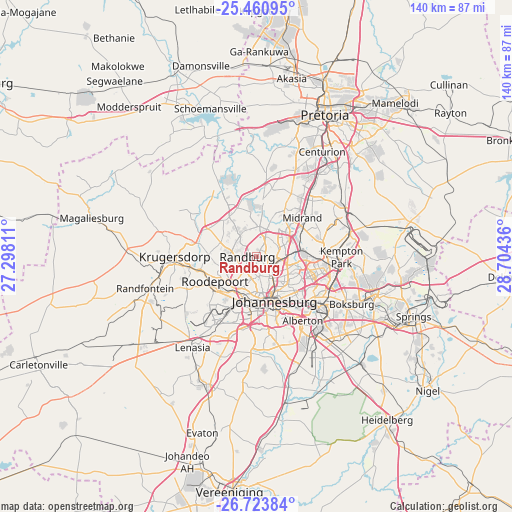
Randburg GPS coordinates[2]
26° 5' 38.76" South, 28° 0' 4.428" East
| Map corner | latitude | longitude |
|---|---|---|
| Upper-left | -25.46095°, | 27.29811° |
| Center: | -26.0941°, | 28.00123° |
| Lower-right: | -26.72384°, | 28.70436° |
| Map W x H: | 140.4×140.4 km | = 87.2×87.2mi |
| max Lat: | -22.34881° ⇑18% North |
| Randburg: | -26.0941° |
| min Lat: | ⇓82% South -34.66739° |
| min Long | Randburg | max Long |
| 16.8697° | 28.00123° | 32.26762° |
| W 55.8%⇐ | ⇒44.2% E |
Elevation
Elevation of Randburg is 1593 m = 5226 ft, and this is 623.4 m = 2045 ft above average elevation for this country.
| Max E: |
1873 m = 6145 ft | 11.5% |
| Randburg | 1593 m 5226 ft | |
| Avg. | 969.6 m = 3181 ft | |
Min E: |
7 m = 23 ft | 88.5% |
See also: Randburg elevation on elevation.city.
Geographical zone
Randburg is located in South temperate zone (between Tropic of Capricorn and the Antarctic Circle). Distance of this Southern Tropic circle is 295.5 km =183.6 mi to North.| Distance of | km | miles | from Randburg |
|---|---|---|---|
| Equator | 2901.4 | 1802.8 | to North |
| Tropic Capricorn | 295.5 | 183.6 | to North |
| Antarctic Circle | 4499.8 | 2796 | to South |
| South Pole | 7105.7 | 4415.3 | to South |


Nearby cities:
15 places around Randburg: (largest is in red/bold)
• Alberton
22.8 km =14.2 mi,  147°
147°
• Diepsloot
17.9 km =11.1 mi,  3°
3°
• Eastleigh
15.9 km =9.9 mi,  104°
104°
• Eden Glen
17.2 km =10.7 mi, 104°
• Eden Glen Ext 60
16.7 km =10.4 mi, 102°
• Edenvale
16 km =9.9 mi,  109°
109°
• Germiston
23.5 km =14.6 mi,  131°
131°
• Johannesburg
12.8 km =8 mi,  160°
160°
• Krugersdorp
22.6 km =14 mi,  272°
272°
• Midrand
17.2 km =10.7 mi,  47°
47°
• Modderfontein
16.4 km =10.2 mi,  88°
88°
• Muldersdriseloop
17.5 km =10.9 mi,  291°
291°
• Riverlea
13.4 km =8.3 mi,  192°
192°
• Roodepoort
14.9 km =9.3 mi,  239°
239°
• Soweto
24 km =14.9 mi,  216°
216°
Sources, notices
• [Note1] Compared only with cities in South Africa existing in our database
• [Src1] Map data: © OpenStreetMap contributors (CC-BY-SA)
• [Src2] Other city data from geonames.org with taken over terms of usage.
• [Src3] Geographical zone / Annual Mean Temperature by Robert A. Rohde @ Wikipedia
