Modderfontein geodata
Modderfontein (Gauteng) is a populated place; located in South Africa in Africa/Johannesburg (GMT+2) time zone. With population of 3,000 people, there are 246 cities with bigger population in this country. Compared to other cities in South Africa, 82.3% of cities are located further ↓South; 59.6% of cities are located further ←West and 91.7% of cities have lower elevation than Modderfontein. Note1
Administrative division(s):
- Level 1: Gauteng
- Level 2: City of Johannesburg Metropolitan Municipality
- Level 3: City of Johannesburg


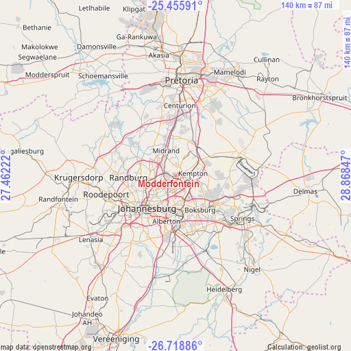
Modderfontein GPS coordinates[2]
26° 5' 20.724" South, 28° 9' 55.224" East
| Map corner | latitude | longitude |
|---|---|---|
| Upper-left | -25.45591°, | 27.46222° |
| Center: | -26.08909°, | 28.16534° |
| Lower-right: | -26.71886°, | 28.86847° |
| Map W x H: | 140.4×140.4 km | = 87.2×87.2mi |
| max Lat: | -22.34881° ⇑17.7% North |
| Modderfontein: | -26.08909° |
| min Lat: | ⇓82.3% South -34.66739° |
| min Long | Modderfontein | max Long |
| 16.8697° | 28.16534° | 32.26762° |
| W 59.6%⇐ | ⇒40.4% E |
Elevation
Elevation of Modderfontein is 1625 m = 5331 ft, and this is 655.4 m = 2150 ft above average elevation for this country.
| Max E: |
1873 m = 6145 ft | 8.3% |
| Modderfontein | 1625 m 5331 ft | |
| Avg. | 969.6 m = 3181 ft | |
Min E: |
7 m = 23 ft | 91.7% |
See also: South Africa elevation on elevation.city.
Geographical zone
Modderfontein is located in South temperate zone (between Tropic of Capricorn and the Antarctic Circle). Distance of this Southern Tropic circle is 294.9 km =183.2 mi to North.| Distance of | km | miles | from Modderfontein |
|---|---|---|---|
| Equator | 2900.8 | 1802.5 | to North |
| Tropic Capricorn | 294.9 | 183.2 | to North |
| Antarctic Circle | 4500.3 | 2796.4 | to South |
| South Pole | 7106.2 | 4415.6 | to South |


Nearby cities:
15 places around Modderfontein: (largest is in red/bold)
• Alberton
20.3 km =12.6 mi,  192°
192°
• Benoni
19 km =11.8 mi,  125°
125°
• Boksburg
16.6 km =10.3 mi,  145°
145°
• Diepsloot
23.1 km =14.4 mi,  318°
318°
• Eastleigh
4.6 km =2.9 mi, 192°
• Eden Glen
4.8 km =3 mi,  176°
176°
• Eden Glen Ext 60
4.1 km =2.5 mi, 180°
• Edenvale
5.9 km =3.7 mi, 192°
• Germiston
16.2 km =10.1 mi, 176°
• Johannesburg
17.5 km =10.9 mi,  223°
223°
• Midrand
11.7 km =7.3 mi,  341°
341°
• Midstream
19.3 km =12 mi,  10°
10°
• Randburg
16.4 km =10.2 mi,  268°
268°
• Riverlea
23.5 km =14.6 mi,  234°
234°
• Tembisa
12 km =7.5 mi,  30°
30°
Sources, notices
• [Note1] Compared only with cities in South Africa existing in our database
• [Src1] Map data: © OpenStreetMap contributors (CC-BY-SA)
• [Src2] Other city data from geonames.org with taken over terms of usage.
• [Src3] Geographical zone / Annual Mean Temperature by Robert A. Rohde @ Wikipedia
