Diepsloot geodata
Diepsloot (Gauteng) is a section of populated place; located in South Africa in Africa/Johannesburg (GMT+2) time zone. With population of 350,000 people, there are 16 cities with bigger population in this country. Compared to other cities in South Africa, 84.1% of cities are located further ↓South; 56% of cities are located further ←West and 74% of cities have lower elevation than Diepsloot. Note1
Administrative division(s):
- Level 1: Gauteng
- Level 2: City of Johannesburg Metropolitan Municipality
- Level 3: City of Johannesburg


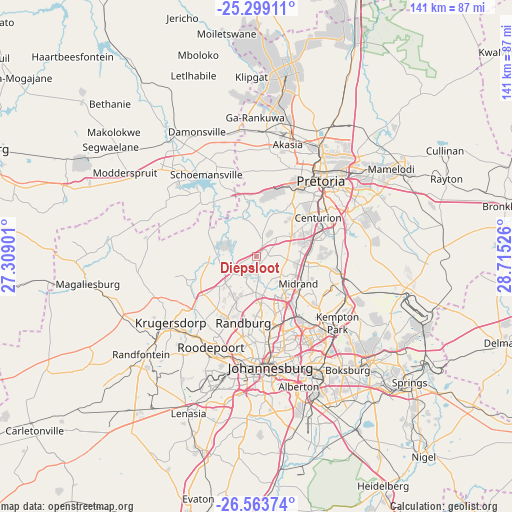
Diepsloot GPS coordinates[2]
25° 55' 59.232" South, 28° 0' 43.668" East
| Map corner | latitude | longitude |
|---|---|---|
| Upper-left | -25.29911°, | 27.30901° |
| Center: | -25.93312°, | 28.01213° |
| Lower-right: | -26.56374°, | 28.71526° |
| Map W x H: | 140.6×140.6 km | = 87.4×87.4mi |
| max Lat: | -22.34881° ⇑15.9% North |
| Diepsloot: | -25.93312° |
| min Lat: | ⇓84.1% South -34.66739° |
| min Long | Diepsloot | max Long |
| 16.8697° | 28.01213° | 32.26762° |
| W 56%⇐ | ⇒44% E |
Elevation
Elevation of Diepsloot is 1410 m = 4626 ft, and this is 440.4 m = 1445 ft above average elevation for this country.
| Max E: |
1873 m = 6145 ft | 26% |
| Diepsloot | 1410 m 4626 ft | |
| Avg. | 969.6 m = 3181 ft | |
Min E: |
7 m = 23 ft | 74% |
See also: Diepsloot elevation on elevation.city.
Geographical zone
Diepsloot is located in South temperate zone (between Tropic of Capricorn and the Antarctic Circle). Distance of this Southern Tropic circle is 277.6 km =172.5 mi to North.| Distance of | km | miles | from Diepsloot |
|---|---|---|---|
| Equator | 2883.5 | 1791.7 | to North |
| Tropic Capricorn | 277.6 | 172.5 | to North |
| Antarctic Circle | 4517.7 | 2807.2 | to South |
| South Pole | 7123.6 | 4426.4 | to South |


Nearby cities:
15 places around Diepsloot: (largest is in red/bold)
• Centurion
19.2 km =11.9 mi,  64°
64°
• Eastleigh
26.1 km =16.2 mi,  146°
146°
• Eden Glen
27.1 km =16.8 mi,  144°
144°
• Eden Glen Ext 60
26.3 km =16.3 mi, 144°
• Edenvale
27 km =16.8 mi, 148°
• Johannesburg
30.1 km =18.7 mi,  173°
173°
• Krugersdorp
29.1 km =18.1 mi,  234°
234°
• Midrand
13.2 km =8.2 mi,  118°
118°
• Midstream
18.7 km =11.6 mi,  85°
85°
• Modderfontein
23.1 km =14.4 mi, 138°
• Muldersdriseloop
20.9 km =13 mi,  236°
236°
• Pretoria
27.3 km =17 mi,  40°
40°
• Randburg
17.9 km =11.1 mi,  183°
183°
• Roodepoort
29.1 km =18.1 mi,  208°
208°
• Tembisa
22.6 km =14 mi,  108°
108°
Sources, notices
• [Note1] Compared only with cities in South Africa existing in our database
• [Src1] Map data: © OpenStreetMap contributors (CC-BY-SA)
• [Src2] Other city data from geonames.org with taken over terms of usage.
• [Src3] Geographical zone / Annual Mean Temperature by Robert A. Rohde @ Wikipedia
