Xhafzotaj geodata
Xhafzotaj (Durrës) is a seat of a third-order administrative division; located in Albania in Europe/Tirane (GMT+2) time zone. In our database, there are 71 cities with bigger population. Compared to other cities in Albania, 63.9% of cities are located further ↓South; 92.4% of cities are located further →East and 88.5% of cities have higher elevation than Xhafzotaj. Note1


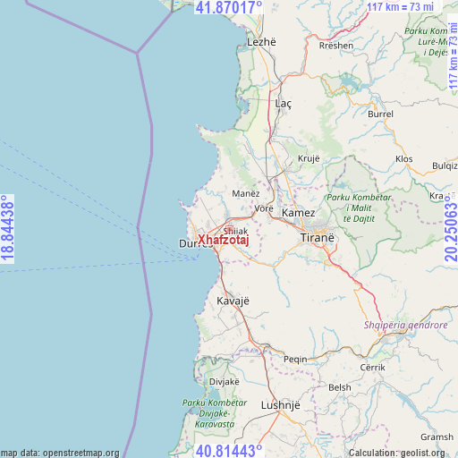
Xhafzotaj GPS coordinates[2]
41° 20' 39.984" North, 19° 32' 51" East
| Map corner | latitude | longitude |
|---|---|---|
| Upper-left | 41.87017°, | 18.84438° |
| Center: | 41.34444°, | 19.5475° |
| Lower-right: | 40.81443°, | 20.25063° |
| Map W x H: | 117.4×117.4 km | = 72.9×72.9mi |
| max Lat: | 42.45139° ⇑36.1% North |
| Xhafzotaj: | 41.34444° |
| min Lat: | ⇓63.9% South 39.65889° |
| min Long | Xhafzotaj | max Long |
| 19.40556° | 19.5475° | 20.99° |
| W 7.6%⇐ | ⇒92.4% E |
Elevation
Elevation of Xhafzotaj is 19 m = 62 ft, and this is 355.6 m = 1167 ft below average elevation for this country.
| Max E: |
1352 m = 4436 ft | 88.5% |
| Avg. | 374.6 m = 1229 ft | |
| Xhafzotaj | 19 m = 62 ft | |
Min E: |
-2 m = -7 ft | 11.5% |
See also: Albania elevation on elevation.city.
Geographical zone
Xhafzotaj is located in North temperate zone (between Tropic of Cancer and the Arctic Circle). Distance of this Northern Tropic circle is 1991.2 km =1237.3 mi to South.| Distance of | km | miles | from Xhafzotaj |
|---|---|---|---|
| North Pole | 5410 | 3361.6 | to North |
| Arctic Circle | 2804.1 | 1742.4 | to North |
| Tropic Cancer | 1991.2 | 1237.3 | to South |
| Equator | 4597.1 | 2856.5 | to South |


Nearby cities:
15 places around Xhafzotaj: (largest is in red/bold)
• Bubq
16.8 km =10.4 mi,  31°
31°
• Bërxull
12.3 km =7.6 mi,  71°
71°
• Durrës
8.1 km =5 mi,  253°
253°
• Gjepalaj
2.8 km =1.7 mi,  116°
116°
• Golem
11 km =6.8 mi,  185°
185°
• Kashar
13.6 km =8.5 mi,  87°
87°
• Katundi i Ri
7 km =4.3 mi,  339°
339°
• Maminas
6.3 km =3.9 mi,  52°
52°
• Manzë
10.1 km =6.3 mi,  22°
22°
• Ndroq
12.7 km =7.9 mi,  134°
134°
• Prezë
13.9 km =8.6 mi, 48°
• Rrashbull
3.9 km =2.4 mi,  232°
232°
• Shijak
1.7 km =1.1 mi, 85°
• Sukth
4.1 km =2.5 mi,  348°
348°
• Vorë
10.3 km =6.4 mi,  60°
60°
Sources, notices
• [Note1] Compared only with cities in Albania existing in our database
• [Src1] Map data: © OpenStreetMap contributors (CC-BY-SA)
• [Src2] Other city data from geonames.org with taken over terms of usage.
• [Src3] Geographical zone / Annual Mean Temperature by Robert A. Rohde @ Wikipedia
