Durrës geodata
Durrës is a seat of a first-order administrative division; located in Albania in Europe/Tirane (GMT+2) time zone. With population of 122,034 people, there is 1 city with bigger population in this country. Compared to other cities in Albania, 62.8% of cities are located further ↓South; 98.6% of cities are located further →East and 97.7% of cities have higher elevation than Durrës. Note1


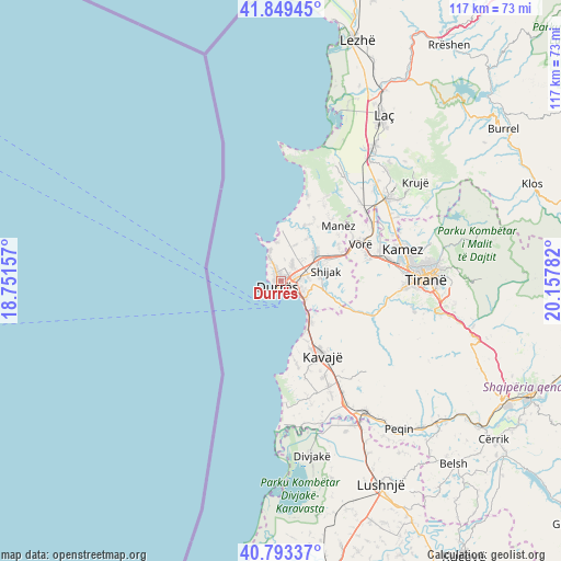
Durrës GPS coordinates[2]
41° 19' 24.78" North, 19° 27' 16.884" East
| Map corner | latitude | longitude |
|---|---|---|
| Upper-left | 41.84945°, | 18.75157° |
| Center: | 41.32355°, | 19.45469° |
| Lower-right: | 40.79337°, | 20.15782° |
| Map W x H: | 117.4×117.4 km | = 72.9×72.9mi |
| max Lat: | 42.45139° ⇑37.2% North |
| Durrës: | 41.32355° |
| min Lat: | ⇓62.8% South 39.65889° |
| min Long | Durrës | max Long |
| 19.40556° | 19.45469° | 20.99° |
| W 1.4%⇐ | ⇒98.6% E |
Elevation
Elevation of Durrës is 6 m = 20 ft, and this is 368.6 m = 1209 ft below average elevation for this country.
| Max E: |
1352 m = 4436 ft | 97.7% |
| Avg. | 374.6 m = 1229 ft | |
| Durrës | 6 m = 20 ft | |
Min E: |
-2 m = -7 ft | 2.3% |
See also: Durrës elevation on elevation.city.
Geographical zone
Durrës is located in North temperate zone (between Tropic of Cancer and the Arctic Circle). Distance of this Northern Tropic circle is 1988.8 km =1235.8 mi to South.| Distance of | km | miles | from Durrës |
|---|---|---|---|
| North Pole | 5412.3 | 3363 | to North |
| Arctic Circle | 2806.4 | 1743.8 | to North |
| Tropic Cancer | 1988.8 | 1235.8 | to South |
| Equator | 4594.7 | 2855 | to South |


Nearby cities:
15 places around Durrës: (largest is in red/bold)
• Bërxull
20.4 km =12.7 mi,  72°
72°
• Gjepalaj
10.4 km =6.5 mi,  84°
84°
• Golem
10.9 km =6.8 mi,  142°
142°
• Katundi i Ri
10.3 km =6.4 mi,  30°
30°
• Kavajë
17.6 km =10.9 mi,  150°
150°
• Maminas
14.2 km =8.8 mi,  64°
64°
• Manzë
16.4 km =10.2 mi,  44°
44°
• Ndroq
18.1 km =11.2 mi,  111°
111°
• Rrashbull
4.6 km =2.9 mi,  91°
91°
• Shijak
9.7 km =6 mi, 75°
• Shëngjergj
16.9 km =10.5 mi,  157°
157°
• Sukth
9.4 km =5.8 mi,  47°
47°
• Synej
17.6 km =10.9 mi, 155°
• Vorë
18.3 km =11.4 mi, 65°
• Xhafzotaj
8.1 km =5 mi, 73°
Sources, notices
• [Note1] Compared only with cities in Albania existing in our database
• [Src1] Map data: © OpenStreetMap contributors (CC-BY-SA)
• [Src2] Other city data from geonames.org with taken over terms of usage.
• [Src3] Geographical zone / Annual Mean Temperature by Robert A. Rohde @ Wikipedia
