Ungrej geodata
Ungrej (Lezhë) is a seat of a third-order administrative division; located in Albania in Europe/Tirane (GMT+2) time zone. In our database, there are 71 cities with bigger population. Compared to other cities in Albania, 85.1% of cities are located further ↓South; 65.9% of cities are located further →East and 52.4% of cities have higher elevation than Ungrej. Note1


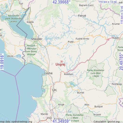
Ungrej GPS coordinates[2]
41° 52' 31.008" North, 19° 47' 40.992" East
| Map corner | latitude | longitude |
|---|---|---|
| Upper-left | 42.39668°, | 19.0916° |
| Center: | 41.87528°, | 19.79472° |
| Lower-right: | 41.34959°, | 20.49785° |
| Map W x H: | 116.4×116.4 km | = 72.3×72.3mi |
| max Lat: | 42.45139° ⇑14.9% North |
| Ungrej: | 41.87528° |
| min Lat: | ⇓85.1% South 39.65889° |
| min Long | Ungrej | max Long |
| 19.40556° | 19.79472° | 20.99° |
| W 34.1%⇐ | ⇒65.9% E |
Elevation
Elevation of Ungrej is 253 m = 830 ft, and this is 121.6 m = 399 ft below average elevation for this country.
| Max E: |
1352 m = 4436 ft | 52.4% |
| Avg. | 374.6 m = 1229 ft | |
| Ungrej | 253 m = 830 ft | |
Min E: |
-2 m = -7 ft | 47.6% |
See also: Albania elevation on elevation.city.
Geographical zone
Ungrej is located in North temperate zone (between Tropic of Cancer and the Arctic Circle). Distance of this Northern Tropic circle is 2050.2 km =1273.9 mi to South.| Distance of | km | miles | from Ungrej |
|---|---|---|---|
| North Pole | 5351 | 3325 | to North |
| Arctic Circle | 2745.1 | 1705.7 | to North |
| Tropic Cancer | 2050.2 | 1273.9 | to South |
| Equator | 4656.1 | 2893.2 | to South |


Nearby cities:
15 places around Ungrej: (largest is in red/bold)
• Balldreni i Ri
14.2 km =8.8 mi,  244°
244°
• Blinisht
17.1 km =10.6 mi,  95°
95°
• Dajç
16.4 km =10.2 mi,  285°
285°
• Gjegjan
19.2 km =11.9 mi,  68°
68°
• Hajmel
15.6 km =9.7 mi,  303°
303°
• Kallmeti i Madh
9.4 km =5.8 mi,  251°
251°
• Kaçinar
8.8 km =5.5 mi,  76°
76°
• Kolç
13.9 km =8.6 mi,  224°
224°
• Lezhë
16.1 km =10 mi,  230°
230°
• Qerret
20.1 km =12.5 mi,  10°
10°
• Rrëshen
13.7 km =8.5 mi,  150°
150°
• Rubik
11.2 km =7 mi,  183°
183°
• Shëngjin
18 km =11.2 mi, 247°
• Vau i Dejës
20.5 km =12.7 mi,  316°
316°
• Zejmen
20.6 km =12.8 mi,  205°
205°
Sources, notices
• [Note1] Compared only with cities in Albania existing in our database
• [Src1] Map data: © OpenStreetMap contributors (CC-BY-SA)
• [Src2] Other city data from geonames.org with taken over terms of usage.
• [Src3] Geographical zone / Annual Mean Temperature by Robert A. Rohde @ Wikipedia
