Ulëz geodata
Ulëz (Dibër) is a seat of a third-order administrative division; located in Albania in Europe/Tirane (GMT+2) time zone. With population of 4 people, there are 70 cities with bigger population in this country. Compared to other cities in Albania, 77.7% of cities are located further ↓South; 58% of cities are located further →East and 60.8% of cities have higher elevation than Ulëz. Note1


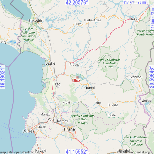
Ulëz GPS coordinates[2]
41° 40' 58.008" North, 19° 53' 35.988" East
| Map corner | latitude | longitude |
|---|---|---|
| Upper-left | 42.20576°, | 19.19021° |
| Center: | 41.68278°, | 19.89333° |
| Lower-right: | 41.15552°, | 20.59646° |
| Map W x H: | 116.8×116.8 km | = 72.6×72.6mi |
| max Lat: | 42.45139° ⇑22.3% North |
| Ulëz: | 41.68278° |
| min Lat: | ⇓77.7% South 39.65889° |
| min Long | Ulëz | max Long |
| 19.40556° | 19.89333° | 20.99° |
| W 42%⇐ | ⇒58% E |
Elevation
Elevation of Ulëz is 162 m = 531 ft, and this is 212.6 m = 698 ft below average elevation for this country.
| Max E: |
1352 m = 4436 ft | 60.8% |
| Avg. | 374.6 m = 1229 ft | |
| Ulëz | 162 m = 531 ft | |
Min E: |
-2 m = -7 ft | 39.2% |
See also: Albania elevation on elevation.city.
Geographical zone
Ulëz is located in North temperate zone (between Tropic of Cancer and the Arctic Circle). Distance of this Northern Tropic circle is 2028.8 km =1260.6 mi to South.| Distance of | km | miles | from Ulëz |
|---|---|---|---|
| North Pole | 5372.4 | 3338.3 | to North |
| Arctic Circle | 2766.5 | 1719 | to North |
| Tropic Cancer | 2028.8 | 1260.6 | to South |
| Equator | 4634.7 | 2879.9 | to South |


Nearby cities:
15 places around Ulëz: (largest is in red/bold)
• Baz
6.4 km =4 mi,  152°
152°
• Burrel
12.5 km =7.8 mi,  130°
130°
• Derjan
13.7 km =8.5 mi,  94°
94°
• Gurra e Vogël
18.2 km =11.3 mi, 153°
• Kombësi
13.6 km =8.5 mi, 145°
• Laç
15.9 km =9.9 mi,  250°
250°
• Lis
17.1 km =10.6 mi,  111°
111°
• Macukull
18 km =11.2 mi, 87°
• Milot
14.8 km =9.2 mi,  270°
270°
• Rrëshen
9.5 km =5.9 mi,  351°
351°
• Rubik
13.5 km =8.4 mi,  318°
318°
• Rukaj
10.5 km =6.5 mi, 89°
• Selitë
12.6 km =7.8 mi, 245°
• Suç
17.6 km =10.9 mi, 131°
• Zejmen
17.2 km =10.7 mi,  279°
279°
Sources, notices
• [Note1] Compared only with cities in Albania existing in our database
• [Src1] Map data: © OpenStreetMap contributors (CC-BY-SA)
• [Src2] Other city data from geonames.org with taken over terms of usage.
• [Src3] Geographical zone / Annual Mean Temperature by Robert A. Rohde @ Wikipedia
