Laç geodata
Laç (Lezhë) is a seat of a second-order administrative division; located in Albania in Europe/Tirane (GMT+2) time zone. With population of 24,825 people, there are 13 cities with bigger population in this country. Compared to other cities in Albania, 76.3% of cities are located further ↓South; 74.6% of cities are located further →East and 81.7% of cities have higher elevation than Laç. Note1


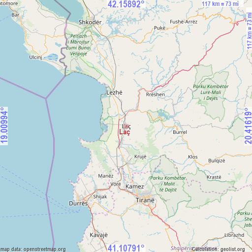
Laç GPS coordinates[2]
41° 38' 8.016" North, 19° 42' 47.016" East
| Map corner | latitude | longitude |
|---|---|---|
| Upper-left | 42.15892°, | 19.00994° |
| Center: | 41.63556°, | 19.71306° |
| Lower-right: | 41.10791°, | 20.41619° |
| Map W x H: | 116.9×116.9 km | = 72.6×72.6mi |
| max Lat: | 42.45139° ⇑23.7% North |
| Laç: | 41.63556° |
| min Lat: | ⇓76.3% South 39.65889° |
| min Long | Laç | max Long |
| 19.40556° | 19.71306° | 20.99° |
| W 25.4%⇐ | ⇒74.6% E |
Elevation
Elevation of Laç is 33 m = 108 ft, and this is 341.6 m = 1121 ft below average elevation for this country.
| Max E: |
1352 m = 4436 ft | 81.7% |
| Avg. | 374.6 m = 1229 ft | |
| Laç | 33 m = 108 ft | |
Min E: |
-2 m = -7 ft | 18.3% |
See also: Albania elevation on elevation.city.
Geographical zone
Laç is located in North temperate zone (between Tropic of Cancer and the Arctic Circle). Distance of this Northern Tropic circle is 2023.5 km =1257.3 mi to South.| Distance of | km | miles | from Laç |
|---|---|---|---|
| North Pole | 5377.6 | 3341.5 | to North |
| Arctic Circle | 2771.7 | 1722.3 | to North |
| Tropic Cancer | 2023.5 | 1257.3 | to South |
| Equator | 4629.4 | 2876.6 | to South |


Nearby cities:
15 places around Laç: (largest is in red/bold)
• Fushë-Krujë
17.5 km =10.9 mi,  178°
178°
• Fushëkuqe
7.9 km =4.9 mi,  281°
281°
• Hasan
17 km =10.6 mi, 183°
• Ishëm
13.8 km =8.6 mi,  223°
223°
• Kolç
17.1 km =10.6 mi,  349°
349°
• Krujë
15.5 km =9.6 mi,  154°
154°
• Lezhë
17.4 km =10.8 mi,  340°
340°
• Mamurras
6.7 km =4.2 mi,  195°
195°
• Milot
5.4 km =3.4 mi,  2°
2°
• Rubik
16.6 km =10.3 mi,  21°
21°
• Selitë
3.5 km =2.2 mi,  90°
90°
• Shënkoll
7.9 km =4.9 mi,  321°
321°
• Thumanë
10.2 km =6.3 mi, 196°
• Ulëz
15.9 km =9.9 mi,  70°
70°
• Zejmen
8.3 km =5.2 mi, 346°
Sources, notices
• [Note1] Compared only with cities in Albania existing in our database
• [Src1] Map data: © OpenStreetMap contributors (CC-BY-SA)
• [Src2] Other city data from geonames.org with taken over terms of usage.
• [Src3] Geographical zone / Annual Mean Temperature by Robert A. Rohde @ Wikipedia
