Burrel geodata
Burrel (Dibër) is a seat of a second-order administrative division; located in Albania in Europe/Tirane (GMT+2) time zone. With population of 15,405 people, there are 20 cities with bigger population in this country. Compared to other cities in Albania, 74.9% of cities are located further ↓South; 51.8% of cities are located further ←West and 53% of cities have lower elevation than Burrel. Note1


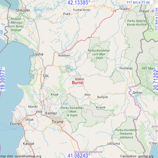
Burrel GPS coordinates[2]
41° 36' 37.008" North, 20° 0' 32.004" East
| Map corner | latitude | longitude |
|---|---|---|
| Upper-left | 42.13385°, | 19.30577° |
| Center: | 41.61028°, | 20.00889° |
| Lower-right: | 41.08243°, | 20.71202° |
| Map W x H: | 116.9×116.9 km | = 72.6×72.6mi |
| max Lat: | 42.45139° ⇑25.1% North |
| Burrel: | 41.61028° |
| min Lat: | ⇓74.9% South 39.65889° |
| min Long | Burrel | max Long |
| 19.40556° | 20.00889° | 20.99° |
| W 51.8%⇐ | ⇒48.2% E |
Elevation
Elevation of Burrel is 315 m = 1033 ft, and this is 59.6 m = 196 ft below average elevation for this country.
| Max E: |
1352 m = 4436 ft | 47% |
| Avg. | 374.6 m = 1229 ft | |
| Burrel | 315 m = 1033 ft | |
Min E: |
-2 m = -7 ft | 53% |
See also: Albania elevation on elevation.city.
Geographical zone
Burrel is located in North temperate zone (between Tropic of Cancer and the Arctic Circle). Distance of this Northern Tropic circle is 2020.7 km =1255.6 mi to South.| Distance of | km | miles | from Burrel |
|---|---|---|---|
| North Pole | 5380.4 | 3343.2 | to North |
| Arctic Circle | 2774.5 | 1724 | to North |
| Tropic Cancer | 2020.7 | 1255.6 | to South |
| Equator | 4626.6 | 2874.8 | to South |


Nearby cities:
15 places around Burrel: (largest is in red/bold)
• Baz
7.1 km =4.4 mi,  289°
289°
• Cudhi Zall
17.6 km =10.9 mi,  230°
230°
• Derjan
8.2 km =5.1 mi,  30°
30°
• Gurra e Vogël
8.4 km =5.2 mi,  190°
190°
• Klos
13.2 km =8.2 mi,  150°
150°
• Kombësi
3.7 km =2.3 mi,  211°
211°
• Kurbnesh
19.8 km =12.3 mi,  18°
18°
• Lis
6.6 km =4.1 mi,  73°
73°
• Macukull
12.1 km =7.5 mi,  44°
44°
• Rrëshen
20.7 km =12.9 mi,  327°
327°
• Rukaj
8.2 km =5.1 mi,  5°
5°
• Suç
5.1 km =3.2 mi,  136°
136°
• Ulëz
12.5 km =7.8 mi,  310°
310°
• Xibër-Murrizë
17.4 km =10.8 mi,  175°
175°
• Zall-Bastar
21.1 km =13.1 mi,  198°
198°
Sources, notices
• [Note1] Compared only with cities in Albania existing in our database
• [Src1] Map data: © OpenStreetMap contributors (CC-BY-SA)
• [Src2] Other city data from geonames.org with taken over terms of usage.
• [Src3] Geographical zone / Annual Mean Temperature by Robert A. Rohde @ Wikipedia
