Derjan geodata
Derjan (Dibër) is a seat of a third-order administrative division; located in Albania in Europe/Tirane (GMT+2) time zone. In our database, there are 71 cities with bigger population. Compared to other cities in Albania, 77.2% of cities are located further ↓South; 56.9% of cities are located further ←West and 64.8% of cities have lower elevation than Derjan. Note1


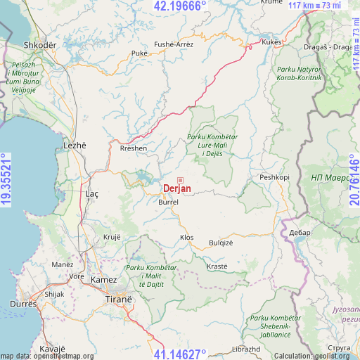
Derjan GPS coordinates[2]
41° 40' 24.996" North, 20° 3' 29.988" East
| Map corner | latitude | longitude |
|---|---|---|
| Upper-left | 42.19666°, | 19.35521° |
| Center: | 41.67361°, | 20.05833° |
| Lower-right: | 41.14627°, | 20.76146° |
| Map W x H: | 116.8×116.8 km | = 72.6×72.6mi |
| max Lat: | 42.45139° ⇑22.8% North |
| Derjan: | 41.67361° |
| min Lat: | ⇓77.2% South 39.65889° |
| min Long | Derjan | max Long |
| 19.40556° | 20.05833° | 20.99° |
| W 56.9%⇐ | ⇒43.1% E |
Elevation
Elevation of Derjan is 477 m = 1565 ft, and this is 102.4 m = 336 ft above average elevation for this country.
| Max E: |
1352 m = 4436 ft | 35.2% |
| Derjan | 477 m 1565 ft | |
| Avg. | 374.6 m = 1229 ft | |
Min E: |
-2 m = -7 ft | 64.8% |
See also: Albania elevation on elevation.city.
Geographical zone
Derjan is located in North temperate zone (between Tropic of Cancer and the Arctic Circle). Distance of this Northern Tropic circle is 2027.8 km =1260 mi to South.| Distance of | km | miles | from Derjan |
|---|---|---|---|
| North Pole | 5373.4 | 3338.9 | to North |
| Arctic Circle | 2767.5 | 1719.6 | to North |
| Tropic Cancer | 2027.8 | 1260 | to South |
| Equator | 4633.7 | 2879.2 | to South |


Nearby cities:
15 places around Derjan: (largest is in red/bold)
• Baz
11.7 km =7.3 mi,  246°
246°
• Burrel
8.2 km =5.1 mi,  210°
210°
• Gurra e Vogël
16.3 km =10.1 mi,  200°
200°
• Klos
18.7 km =11.6 mi,  172°
172°
• Kombësi
11.9 km =7.4 mi, 210°
• Kthella e Epërme
15.4 km =9.6 mi,  0°
0°
• Kurbnesh
12 km =7.5 mi,  10°
10°
• Lis
5.6 km =3.5 mi,  156°
156°
• Macukull
4.6 km =2.9 mi,  68°
68°
• Orosh
17.9 km =11.1 mi, 6°
• Rrëshen
18.4 km =11.4 mi,  304°
304°
• Rukaj
3.4 km =2.1 mi,  288°
288°
• Selishtë
19.1 km =11.9 mi,  105°
105°
• Suç
10.8 km =6.7 mi,  183°
183°
• Ulëz
13.7 km =8.5 mi,  274°
274°
Sources, notices
• [Note1] Compared only with cities in Albania existing in our database
• [Src1] Map data: © OpenStreetMap contributors (CC-BY-SA)
• [Src2] Other city data from geonames.org with taken over terms of usage.
• [Src3] Geographical zone / Annual Mean Temperature by Robert A. Rohde @ Wikipedia
