Banaj geodata
Banaj (Berat) is a populated place; located in Albania in Europe/Tirane (GMT+2) time zone. With population of 2,500 people, there are 60 cities with bigger population in this country. Compared to other cities in Albania, 62.8% of cities are located further ↑North; 62% of cities are located further →East and 90.1% of cities have higher elevation than Banaj. Note1


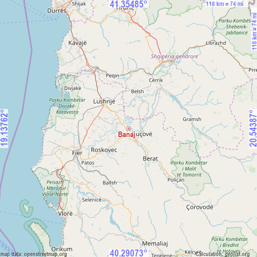
Banaj GPS coordinates[2]
40° 49' 29.712" North, 19° 50' 26.664" East
| Map corner | latitude | longitude |
|---|---|---|
| Upper-left | 41.35485°, | 19.13762° |
| Center: | 40.82492°, | 19.84074° |
| Lower-right: | 40.29073°, | 20.54387° |
| Map W x H: | 118.3×118.3 km | = 73.5×73.5mi |
| max Lat: | 42.45139° ⇑62.8% North |
| Banaj: | 40.82492° |
| min Lat: | ⇓37.2% South 39.65889° |
| min Long | Banaj | max Long |
| 19.40556° | 19.84074° | 20.99° |
| W 38%⇐ | ⇒62% E |
Elevation
Elevation of Banaj is 17 m = 56 ft, and this is 357.6 m = 1173 ft below average elevation for this country.
| Max E: |
1352 m = 4436 ft | 90.1% |
| Avg. | 374.6 m = 1229 ft | |
| Banaj | 17 m = 56 ft | |
Min E: |
-2 m = -7 ft | 9.9% |
See also: Albania elevation on elevation.city.
Geographical zone
Banaj is located in North temperate zone (between Tropic of Cancer and the Arctic Circle). Distance of this Northern Tropic circle is 1933.4 km =1201.4 mi to South.| Distance of | km | miles | from Banaj |
|---|---|---|---|
| North Pole | 5467.8 | 3397.5 | to North |
| Arctic Circle | 2861.9 | 1778.3 | to North |
| Tropic Cancer | 1933.4 | 1201.4 | to South |
| Equator | 4539.3 | 2820.6 | to South |


Nearby cities:
15 places around Banaj: (largest is in red/bold)
• Allkaj
8 km =5 mi,  296°
296°
• Cukalat
11.3 km =7 mi,  201°
201°
• Dushk
13 km =8.1 mi,  212°
212°
• Fier-Shegan
6.6 km =4.1 mi,  315°
315°
• Fierzë
10.6 km =6.6 mi,  2°
2°
• Kajan
10.7 km =6.6 mi,  22°
22°
• Kozarë
5.1 km =3.2 mi,  82°
82°
• Kurjan
14.4 km =8.9 mi, 213°
• Kutalli
6.4 km =4 mi,  224°
224°
• Kuçovë
7 km =4.3 mi,  113°
113°
• Otllak
12 km =7.5 mi,  138°
138°
• Perondi
8.6 km =5.3 mi,  126°
126°
• Poshnje
5 km =3.1 mi,  176°
176°
• Strum
12 km =7.5 mi,  226°
226°
• Ura Vajgurore
7 km =4.3 mi,  153°
153°
Sources, notices
• [Note1] Compared only with cities in Albania existing in our database
• [Src1] Map data: © OpenStreetMap contributors (CC-BY-SA)
• [Src2] Other city data from geonames.org with taken over terms of usage.
• [Src3] Geographical zone / Annual Mean Temperature by Robert A. Rohde @ Wikipedia
