Ura Vajgurore geodata
Ura Vajgurore (Berat) is a seat of a third-order administrative division; located in Albania in Europe/Tirane (GMT+2) time zone. With population of 4,893 people, there are 47 cities with bigger population in this country. Compared to other cities in Albania, 66.5% of cities are located further ↑North; 59.2% of cities are located further →East and 81.7% of cities have higher elevation than Ura Vajgurore. Note1


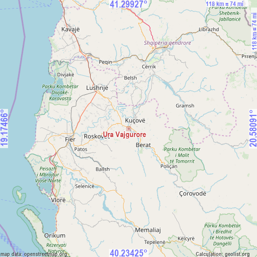
Ura Vajgurore GPS coordinates[2]
40° 46' 8.004" North, 19° 52' 40.008" East
| Map corner | latitude | longitude |
|---|---|---|
| Upper-left | 41.29927°, | 19.17466° |
| Center: | 40.76889°, | 19.87778° |
| Lower-right: | 40.23425°, | 20.58091° |
| Map W x H: | 118.4×118.4 km | = 73.6×73.6mi |
| max Lat: | 42.45139° ⇑66.5% North |
| Ura Vajgurore: | 40.76889° |
| min Lat: | ⇓33.5% South 39.65889° |
| min Long | Ura Vajgurore | max Long |
| 19.40556° | 19.87778° | 20.99° |
| W 40.8%⇐ | ⇒59.2% E |
Elevation
Elevation of Ura Vajgurore is 33 m = 108 ft, and this is 341.6 m = 1121 ft below average elevation for this country.
| Max E: |
1352 m = 4436 ft | 81.7% |
| Avg. | 374.6 m = 1229 ft | |
| Ura Vajgurore | 33 m = 108 ft | |
Min E: |
-2 m = -7 ft | 18.3% |
See also: Albania elevation on elevation.city.
Geographical zone
Ura Vajgurore is located in North temperate zone (between Tropic of Cancer and the Arctic Circle). Distance of this Northern Tropic circle is 1927.2 km =1197.5 mi to South.| Distance of | km | miles | from Ura Vajgurore |
|---|---|---|---|
| North Pole | 5474 | 3401.4 | to North |
| Arctic Circle | 2868.1 | 1782.2 | to North |
| Tropic Cancer | 1927.2 | 1197.5 | to South |
| Equator | 4533.1 | 2816.7 | to South |


Nearby cities:
15 places around Ura Vajgurore: (largest is in red/bold)
• Banaj
7 km =4.3 mi,  333°
333°
• Berat
9.4 km =5.8 mi,  138°
138°
• Cukalat
8.5 km =5.3 mi,  239°
239°
• Dushk
11.2 km =7 mi,  245°
245°
• Fier-Shegan
13.4 km =8.3 mi,  324°
324°
• Kozarë
7.1 km =4.4 mi,  15°
15°
• Kurjan
12.5 km =7.8 mi, 242°
• Kutalli
7.9 km =4.9 mi,  282°
282°
• Kuçovë
4.8 km =3 mi,  43°
43°
• Otllak
5.6 km =3.5 mi,  119°
119°
• Perondi
4 km =2.5 mi,  73°
73°
• Poshnje
3.1 km =1.9 mi,  294°
294°
• Sinjë
13.5 km =8.4 mi,  183°
183°
• Strum
12 km =7.5 mi,  260°
260°
• Velabisht
8.8 km =5.5 mi,  148°
148°
Sources, notices
• [Note1] Compared only with cities in Albania existing in our database
• [Src1] Map data: © OpenStreetMap contributors (CC-BY-SA)
• [Src2] Other city data from geonames.org with taken over terms of usage.
• [Src3] Geographical zone / Annual Mean Temperature by Robert A. Rohde @ Wikipedia
