Cukalat geodata
Cukalat (Berat) is a seat of a third-order administrative division; located in Albania in Europe/Tirane (GMT+2) time zone. In our database, there are 71 cities with bigger population. Compared to other cities in Albania, 69.3% of cities are located further ↑North; 66.8% of cities are located further →East and 62% of cities have higher elevation than Cukalat. Note1


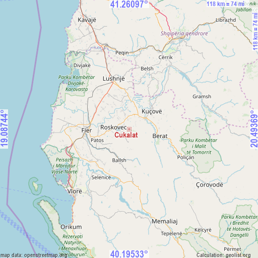
Cukalat GPS coordinates[2]
40° 43' 49.008" North, 19° 47' 26.016" East
| Map corner | latitude | longitude |
|---|---|---|
| Upper-left | 41.26097°, | 19.08744° |
| Center: | 40.73028°, | 19.79056° |
| Lower-right: | 40.19533°, | 20.49369° |
| Map W x H: | 118.5×118.5 km | = 73.6×73.6mi |
| max Lat: | 42.45139° ⇑69.3% North |
| Cukalat: | 40.73028° |
| min Lat: | ⇓30.7% South 39.65889° |
| min Long | Cukalat | max Long |
| 19.40556° | 19.79056° | 20.99° |
| W 33.2%⇐ | ⇒66.8% E |
Elevation
Elevation of Cukalat is 153 m = 502 ft, and this is 221.6 m = 727 ft below average elevation for this country.
| Max E: |
1352 m = 4436 ft | 62% |
| Avg. | 374.6 m = 1229 ft | |
| Cukalat | 153 m = 502 ft | |
Min E: |
-2 m = -7 ft | 38% |
See also: Albania elevation on elevation.city.
Geographical zone
Cukalat is located in North temperate zone (between Tropic of Cancer and the Arctic Circle). Distance of this Northern Tropic circle is 1922.9 km =1194.8 mi to South.| Distance of | km | miles | from Cukalat |
|---|---|---|---|
| North Pole | 5478.3 | 3404.1 | to North |
| Arctic Circle | 2872.4 | 1784.8 | to North |
| Tropic Cancer | 1922.9 | 1194.8 | to South |
| Equator | 4528.8 | 2814.1 | to South |


Nearby cities:
15 places around Cukalat: (largest is in red/bold)
• Banaj
11.3 km =7 mi,  21°
21°
• Dushk
2.8 km =1.7 mi,  261°
261°
• Kuman
8.8 km =5.5 mi,  267°
267°
• Kurjan
4 km =2.5 mi,  249°
249°
• Kutalli
6 km =3.7 mi,  356°
356°
• Ngraçan
9.5 km =5.9 mi,  179°
179°
• Otllak
12.3 km =7.6 mi,  82°
82°
• Perondi
12.4 km =7.7 mi,  64°
64°
• Poshnje
7.2 km =4.5 mi,  39°
39°
• Roskovec
7.5 km =4.7 mi,  276°
276°
• Ruzhdie
10.2 km =6.3 mi,  229°
229°
• Sinjë
11.2 km =7 mi,  144°
144°
• Strum
5 km =3.1 mi,  297°
297°
• Ura Vajgurore
8.5 km =5.3 mi, 59°
• Zharrëz
12.1 km =7.5 mi, 258°
Sources, notices
• [Note1] Compared only with cities in Albania existing in our database
• [Src1] Map data: © OpenStreetMap contributors (CC-BY-SA)
• [Src2] Other city data from geonames.org with taken over terms of usage.
• [Src3] Geographical zone / Annual Mean Temperature by Robert A. Rohde @ Wikipedia
