Shëngjergj geodata
Shëngjergj (Tirana) is a seat of a third-order administrative division; located in Albania in Europe/Tirane (GMT+2) time zone. In our database, there are 71 cities with bigger population. Compared to other cities in Albania, 58% of cities are located further ↓South; 93.5% of cities are located further →East and 96.9% of cities have higher elevation than Shëngjergj. Note1


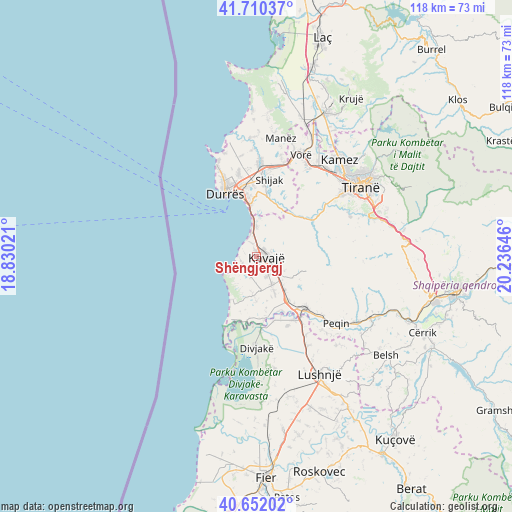
Shëngjergj GPS coordinates[2]
41° 10' 59.988" North, 19° 31' 59.988" East
| Map corner | latitude | longitude |
|---|---|---|
| Upper-left | 41.71037°, | 18.83021° |
| Center: | 41.18333°, | 19.53333° |
| Lower-right: | 40.65202°, | 20.23646° |
| Map W x H: | 117.7×117.7 km | = 73.1×73.1mi |
| max Lat: | 42.45139° ⇑42% North |
| Shëngjergj: | 41.18333° |
| min Lat: | ⇓58% South 39.65889° |
| min Long | Shëngjergj | max Long |
| 19.40556° | 19.53333° | 20.99° |
| W 6.5%⇐ | ⇒93.5% E |
Elevation
Elevation of Shëngjergj is 7 m = 23 ft, and this is 367.6 m = 1206 ft below average elevation for this country.
| Max E: |
1352 m = 4436 ft | 96.9% |
| Avg. | 374.6 m = 1229 ft | |
| Shëngjergj | 7 m = 23 ft | |
Min E: |
-2 m = -7 ft | 3.1% |
See also: Albania elevation on elevation.city.
Geographical zone
Shëngjergj is located in North temperate zone (between Tropic of Cancer and the Arctic Circle). Distance of this Northern Tropic circle is 1973.2 km =1226.1 mi to South.| Distance of | km | miles | from Shëngjergj |
|---|---|---|---|
| North Pole | 5427.9 | 3372.7 | to North |
| Arctic Circle | 2822 | 1753.5 | to North |
| Tropic Cancer | 1973.2 | 1226.1 | to South |
| Equator | 4579.2 | 2845.4 | to South |


Nearby cities:
15 places around Shëngjergj: (largest is in red/bold)
• Durrës
16.9 km =10.5 mi,  337°
337°
• Gjepalaj
17.1 km =10.6 mi,  12°
12°
• Golem
7 km =4.3 mi,  0°
0°
• Gosë e Madhe
12.8 km =8 mi,  143°
143°
• Helmas
6.2 km =3.9 mi,  93°
93°
• Kavajë
2 km =1.2 mi,  82°
82°
• Kryevidh
9.2 km =5.7 mi,  183°
183°
• Lekaj
10 km =6.2 mi, 140°
• Luzi i Vogël
7.1 km =4.4 mi,  151°
151°
• Ndroq
13.6 km =8.5 mi,  48°
48°
• Peza e Madhe
14.1 km =8.8 mi,  74°
74°
• Rrashbull
15.6 km =9.7 mi,  352°
352°
• Rrogozhinë
16.2 km =10.1 mi, 137°
• Synej
0.9 km =0.6 mi,  115°
115°
• Tërbuf
17.3 km =10.7 mi,  156°
156°
Sources, notices
• [Note1] Compared only with cities in Albania existing in our database
• [Src1] Map data: © OpenStreetMap contributors (CC-BY-SA)
• [Src2] Other city data from geonames.org with taken over terms of usage.
• [Src3] Geographical zone / Annual Mean Temperature by Robert A. Rohde @ Wikipedia
