Fushë-Krujë geodata
Fushë-Krujë (Durrës) is a seat of a third-order administrative division; located in Albania in Europe/Tirane (GMT+2) time zone. With population of 10,458 people, there are 33 cities with bigger population in this country. Compared to other cities in Albania, 70.1% of cities are located further ↓South; 73.8% of cities are located further →East and 85.1% of cities have higher elevation than Fushë-Krujë. Note1


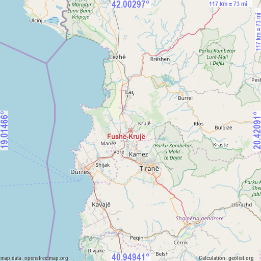
Fushë-Krujë GPS coordinates[2]
41° 28' 41.988" North, 19° 43' 4.008" East
| Map corner | latitude | longitude |
|---|---|---|
| Upper-left | 42.00297°, | 19.01466° |
| Center: | 41.47833°, | 19.71778° |
| Lower-right: | 40.94941°, | 20.42091° |
| Map W x H: | 117.1×117.1 km | = 72.8×72.8mi |
| max Lat: | 42.45139° ⇑29.9% North |
| Fushë-Krujë: | 41.47833° |
| min Lat: | ⇓70.1% South 39.65889° |
| min Long | Fushë-Krujë | max Long |
| 19.40556° | 19.71778° | 20.99° |
| W 26.2%⇐ | ⇒73.8% E |
Elevation
Elevation of Fushë-Krujë is 24 m = 79 ft, and this is 350.6 m = 1150 ft below average elevation for this country.
| Max E: |
1352 m = 4436 ft | 85.1% |
| Avg. | 374.6 m = 1229 ft | |
| Fushë-Krujë | 24 m = 79 ft | |
Min E: |
-2 m = -7 ft | 14.9% |
See also: Albania elevation on elevation.city.
Geographical zone
Fushë-Krujë is located in North temperate zone (between Tropic of Cancer and the Arctic Circle). Distance of this Northern Tropic circle is 2006 km =1246.5 mi to South.| Distance of | km | miles | from Fushë-Krujë |
|---|---|---|---|
| North Pole | 5395.1 | 3352.4 | to North |
| Arctic Circle | 2789.2 | 1733.1 | to North |
| Tropic Cancer | 2006 | 1246.5 | to South |
| Equator | 4612 | 2865.8 | to South |


Nearby cities:
15 places around Fushë-Krujë: (largest is in red/bold)
• Bubq
5.5 km =3.4 mi,  265°
265°
• Bërxull
11.2 km =7 mi,  193°
193°
• Cudhi Zall
11.2 km =7 mi,  72°
72°
• Hasan
1.6 km =1 mi,  288°
288°
• Ishëm
12.3 km =7.6 mi,  307°
307°
• Kallmet
10.9 km =6.8 mi,  127°
127°
• Kamëz
11.3 km =7 mi,  161°
161°
• Krujë
7.1 km =4.4 mi,  61°
61°
• Mamurras
11.2 km =7 mi,  349°
349°
• Manzë
11.8 km =7.3 mi,  241°
241°
• Nikël
4.6 km =2.9 mi,  146°
146°
• Prezë
6.8 km =4.2 mi,  213°
213°
• Thumanë
8.4 km =5.2 mi,  336°
336°
• Vorë
11 km =6.8 mi, 208°
• Zall-Herr
13.5 km =8.4 mi,  137°
137°
Sources, notices
• [Note1] Compared only with cities in Albania existing in our database
• [Src1] Map data: © OpenStreetMap contributors (CC-BY-SA)
• [Src2] Other city data from geonames.org with taken over terms of usage.
• [Src3] Geographical zone / Annual Mean Temperature by Robert A. Rohde @ Wikipedia
