Fier-Shegan geodata
Fier-Shegan (Fier) is a seat of a third-order administrative division; located in Albania in Europe/Tirane (GMT+2) time zone. In our database, there are 71 cities with bigger population. Compared to other cities in Albania, 60.8% of cities are located further ↑North; 67.9% of cities are located further →East and 88.5% of cities have higher elevation than Fier-Shegan. Note1


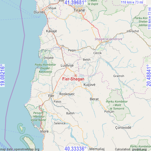
Fier-Shegan GPS coordinates[2]
40° 52' 1.992" North, 19° 47' 7.008" East
| Map corner | latitude | longitude |
|---|---|---|
| Upper-left | 41.39681°, | 19.08216° |
| Center: | 40.86722°, | 19.78528° |
| Lower-right: | 40.33336°, | 20.48841° |
| Map W x H: | 118.2×118.2 km | = 73.4×73.4mi |
| max Lat: | 42.45139° ⇑60.8% North |
| Fier-Shegan: | 40.86722° |
| min Lat: | ⇓39.2% South 39.65889° |
| min Long | Fier-Shegan | max Long |
| 19.40556° | 19.78528° | 20.99° |
| W 32.1%⇐ | ⇒67.9% E |
Elevation
Elevation of Fier-Shegan is 19 m = 62 ft, and this is 355.6 m = 1167 ft below average elevation for this country.
| Max E: |
1352 m = 4436 ft | 88.5% |
| Avg. | 374.6 m = 1229 ft | |
| Fier-Shegan | 19 m = 62 ft | |
Min E: |
-2 m = -7 ft | 11.5% |
See also: Albania elevation on elevation.city.
Geographical zone
Fier-Shegan is located in North temperate zone (between Tropic of Cancer and the Arctic Circle). Distance of this Northern Tropic circle is 1938.1 km =1204.3 mi to South.| Distance of | km | miles | from Fier-Shegan |
|---|---|---|---|
| North Pole | 5463.1 | 3394.6 | to North |
| Arctic Circle | 2857.2 | 1775.4 | to North |
| Tropic Cancer | 1938.1 | 1204.3 | to South |
| Equator | 4544 | 2823.5 | to South |


Nearby cities:
15 places around Fier-Shegan: (largest is in red/bold)
• Allkaj
2.7 km =1.7 mi,  246°
246°
• Banaj
6.6 km =4.1 mi,  135°
135°
• Bubullimë
13.3 km =8.3 mi, 245°
• Fierzë
7.9 km =4.9 mi,  41°
41°
• Hysgjokaj
11.6 km =7.2 mi,  1°
1°
• Kajan
10.2 km =6.3 mi,  59°
59°
• Karbunara e Vogël
8.3 km =5.2 mi,  317°
317°
• Kozarë
10.5 km =6.5 mi,  112°
112°
• Krutja e Poshtme
8.8 km =5.5 mi,  273°
273°
• Kutalli
9.3 km =5.8 mi,  179°
179°
• Kuçovë
13.3 km =8.3 mi,  123°
123°
• Lushnjë
10.7 km =6.6 mi, 320°
• Poshnje
10.9 km =6.8 mi,  152°
152°
• Rrasa e Sipërme
11.6 km =7.2 mi,  15°
15°
• Ura Vajgurore
13.4 km =8.3 mi, 144°
Sources, notices
• [Note1] Compared only with cities in Albania existing in our database
• [Src1] Map data: © OpenStreetMap contributors (CC-BY-SA)
• [Src2] Other city data from geonames.org with taken over terms of usage.
• [Src3] Geographical zone / Annual Mean Temperature by Robert A. Rohde @ Wikipedia
