Trebisht-Muçinë geodata
Trebisht-Muçinë (Dibër) is a seat of a third-order administrative division; located in Albania in Europe/Tirane (GMT+2) time zone. In our database, there are 71 cities with bigger population. Compared to other cities in Albania, 67.6% of cities are located further ↓South; 90.1% of cities are located further ←West and 83.1% of cities have lower elevation than Trebisht-Muçinë. Note1


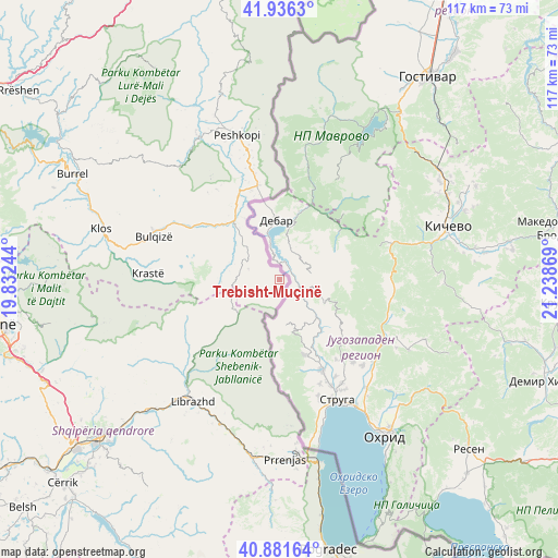
Trebisht-Muçinë GPS coordinates[2]
41° 24' 39.996" North, 20° 32' 8.016" East
| Map corner | latitude | longitude |
|---|---|---|
| Upper-left | 41.9363°, | 19.83244° |
| Center: | 41.41111°, | 20.53556° |
| Lower-right: | 40.88164°, | 21.23869° |
| Map W x H: | 117.3×117.3 km | = 72.9×72.9mi |
| max Lat: | 42.45139° ⇑32.4% North |
| Trebisht-Muçinë: | 41.41111° |
| min Lat: | ⇓67.6% South 39.65889° |
| min Long | Trebisht-Muçin | max Long |
| 19.40556° | 20.53556° | 20.99° |
| W 90.1%⇐ | ⇒9.9% E |
Elevation
Elevation of Trebisht-Muçinë is 790 m = 2592 ft, and this is 415.4 m = 1363 ft above average elevation for this country.
| Max E: |
1352 m = 4436 ft | 16.9% |
| Trebisht-Muçinë | 790 m 2592 ft | |
| Avg. | 374.6 m = 1229 ft | |
Min E: |
-2 m = -7 ft | 83.1% |
See also: Albania elevation on elevation.city.
Geographical zone
Trebisht-Muçinë is located in North temperate zone (between Tropic of Cancer and the Arctic Circle). Distance of this Northern Tropic circle is 1998.6 km =1241.9 mi to South.| Distance of | km | miles | from Trebisht-Muçinë |
|---|---|---|---|
| North Pole | 5402.6 | 3357 | to North |
| Arctic Circle | 2796.7 | 1737.8 | to North |
| Tropic Cancer | 1998.6 | 1241.9 | to South |
| Equator | 4604.5 | 2861.1 | to South |


Nearby cities:
15 places around Trebisht-Muçinë: (largest is in red/bold)
• Bulqizë
27.6 km =17.1 mi,  288°
288°
• Fushë-Bulqizë
24.4 km =15.2 mi,  300°
300°
• Gjorica e Sipërme
15.5 km =9.6 mi,  332°
332°
• Hotolisht
30.6 km =19 mi,  202°
202°
• Librazhd
31.7 km =19.7 mi,  215°
215°
• Librazhd-Qendër
29.1 km =18.1 mi, 215°
• Lunik
22.3 km =13.9 mi,  232°
232°
• Maqellarë
20.2 km =12.6 mi,  347°
347°
• Martanesh
28 km =17.4 mi,  267°
267°
• Melan
27.7 km =17.2 mi, 347°
• Orenjë
30.4 km =18.9 mi,  242°
242°
• Ostreni i Math
7 km =4.3 mi, 288°
• Shupenzë
16.2 km =10.1 mi,  324°
324°
• Steblevë
9.9 km =6.2 mi,  213°
213°
• Zerqan
17.8 km =11.1 mi, 304°
Sources, notices
• [Note1] Compared only with cities in Albania existing in our database
• [Src1] Map data: © OpenStreetMap contributors (CC-BY-SA)
• [Src2] Other city data from geonames.org with taken over terms of usage.
• [Src3] Geographical zone / Annual Mean Temperature by Robert A. Rohde @ Wikipedia
