Kukur geodata
Kukur (Elbasan) is a seat of a third-order administrative division; located in Albania in Europe/Tirane (GMT+2) time zone. In our database, there are 71 cities with bigger population. Compared to other cities in Albania, 60.6% of cities are located further ↑North; 80.3% of cities are located further ←West and 83.9% of cities have lower elevation than Kukur. Note1


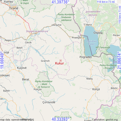
Kukur GPS coordinates[2]
40° 52' 4.008" North, 20° 21' 48.996" East
| Map corner | latitude | longitude |
|---|---|---|
| Upper-left | 41.39736°, | 19.66049° |
| Center: | 40.86778°, | 20.36361° |
| Lower-right: | 40.33393°, | 21.06674° |
| Map W x H: | 118.2×118.2 km | = 73.4×73.4mi |
| max Lat: | 42.45139° ⇑60.6% North |
| Kukur: | 40.86778° |
| min Lat: | ⇓39.4% South 39.65889° |
| min Long | Kukur | max Long |
| 19.40556° | 20.36361° | 20.99° |
| W 80.3%⇐ | ⇒19.7% E |
Elevation
Elevation of Kukur is 797 m = 2615 ft, and this is 422.4 m = 1386 ft above average elevation for this country.
| Max E: |
1352 m = 4436 ft | 16.1% |
| Kukur | 797 m 2615 ft | |
| Avg. | 374.6 m = 1229 ft | |
Min E: |
-2 m = -7 ft | 83.9% |
See also: Albania elevation on elevation.city.
Geographical zone
Kukur is located in North temperate zone (between Tropic of Cancer and the Arctic Circle). Distance of this Northern Tropic circle is 1938.2 km =1204.3 mi to South.| Distance of | km | miles | from Kukur |
|---|---|---|---|
| North Pole | 5463 | 3394.5 | to North |
| Arctic Circle | 2857.1 | 1775.3 | to North |
| Tropic Cancer | 1938.2 | 1204.3 | to South |
| Equator | 4544.1 | 2823.6 | to South |


Nearby cities:
15 places around Kukur: (largest is in red/bold)
• Gramsh
15.1 km =9.4 mi,  270°
270°
• Kodovjat
11.7 km =7.3 mi,  233°
233°
• Kushovë
17.1 km =10.6 mi,  239°
239°
• Lenias
11.5 km =7.1 mi,  168°
168°
• Moglicë
17.8 km =11.1 mi,  159°
159°
• Pishaj
15.3 km =9.5 mi,  275°
275°
• Poroçan
9.9 km =6.2 mi,  326°
326°
• Proptisht
17.6 km =10.9 mi,  41°
41°
• Skënderbegas
14.5 km =9 mi, 225°
• Stravaj
16.1 km =10 mi,  18°
18°
• Trebinjë
16.7 km =10.4 mi,  72°
72°
• Tunjë
21.5 km =13.4 mi,  259°
259°
• Velçan
12.7 km =7.9 mi, 40°
• Zavalinë
14.4 km =8.9 mi, 331°
• Zhepë
22.1 km =13.7 mi,  196°
196°
Sources, notices
• [Note1] Compared only with cities in Albania existing in our database
• [Src1] Map data: © OpenStreetMap contributors (CC-BY-SA)
• [Src2] Other city data from geonames.org with taken over terms of usage.
• [Src3] Geographical zone / Annual Mean Temperature by Robert A. Rohde @ Wikipedia
