Skënderbegas geodata
Skënderbegas (Elbasan) is a seat of a third-order administrative division; located in Albania in Europe/Tirane (GMT+2) time zone. In our database, there are 71 cities with bigger population. Compared to other cities in Albania, 66.2% of cities are located further ↑North; 71.8% of cities are located further ←West and 67.9% of cities have lower elevation than Skënderbegas. Note1


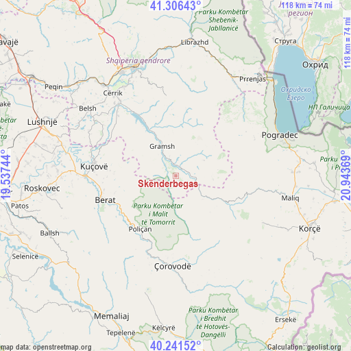
Skënderbegas GPS coordinates[2]
40° 46' 33.996" North, 20° 14' 26.016" East
| Map corner | latitude | longitude |
|---|---|---|
| Upper-left | 41.30643°, | 19.53744° |
| Center: | 40.77611°, | 20.24056° |
| Lower-right: | 40.24152°, | 20.94369° |
| Map W x H: | 118.4×118.4 km | = 73.6×73.6mi |
| max Lat: | 42.45139° ⇑66.2% North |
| Skënderbegas: | 40.77611° |
| min Lat: | ⇓33.8% South 39.65889° |
| min Long | Skënderbegas | max Long |
| 19.40556° | 20.24056° | 20.99° |
| W 71.8%⇐ | ⇒28.2% E |
Elevation
Elevation of Skënderbegas is 521 m = 1709 ft, and this is 146.4 m = 480 ft above average elevation for this country.
| Max E: |
1352 m = 4436 ft | 32.1% |
| Skënderbegas | 521 m 1709 ft | |
| Avg. | 374.6 m = 1229 ft | |
Min E: |
-2 m = -7 ft | 67.9% |
See also: Albania elevation on elevation.city.
Geographical zone
Skënderbegas is located in North temperate zone (between Tropic of Cancer and the Arctic Circle). Distance of this Northern Tropic circle is 1928 km =1198 mi to South.| Distance of | km | miles | from Skënderbegas |
|---|---|---|---|
| North Pole | 5473.2 | 3400.9 | to North |
| Arctic Circle | 2867.3 | 1781.7 | to North |
| Tropic Cancer | 1928 | 1198 | to South |
| Equator | 4533.9 | 2817.2 | to South |


Nearby cities:
15 places around Skënderbegas: (largest is in red/bold)
• Gjerbës
16.4 km =10.2 mi,  176°
176°
• Gramsh
11.4 km =7.1 mi,  335°
335°
• Kodovjat
3.4 km =2.1 mi,  15°
15°
• Kukur
14.5 km =9 mi,  45°
45°
• Kushovë
4.6 km =2.9 mi,  288°
288°
• Lenias
12.7 km =7.9 mi,  94°
94°
• Moglicë
17.8 km =11.1 mi,  111°
111°
• Pishaj
12.6 km =7.8 mi, 337°
• Poliçan
21.8 km =13.5 mi,  213°
213°
• Poroçan
19.1 km =11.9 mi,  14°
14°
• Roshnik
17.6 km =10.9 mi,  254°
254°
• Sult
16.9 km =10.5 mi,  315°
315°
• Tunjë
12.6 km =7.8 mi,  300°
300°
• Vërtop
22.7 km =14.1 mi,  223°
223°
• Zhepë
11.6 km =7.2 mi,  160°
160°
Sources, notices
• [Note1] Compared only with cities in Albania existing in our database
• [Src1] Map data: © OpenStreetMap contributors (CC-BY-SA)
• [Src2] Other city data from geonames.org with taken over terms of usage.
• [Src3] Geographical zone / Annual Mean Temperature by Robert A. Rohde @ Wikipedia
