Kodovjat geodata
Kodovjat (Elbasan) is a seat of a third-order administrative division; located in Albania in Europe/Tirane (GMT+2) time zone. In our database, there are 71 cities with bigger population. Compared to other cities in Albania, 63.7% of cities are located further ↑North; 72.1% of cities are located further ←West and 50.4% of cities have higher elevation than Kodovjat. Note1


Kodovjat GPS coordinates[2]
40° 48' 20.016" North, 20° 15' 3.996" East
| Map corner | latitude | longitude |
|---|---|---|
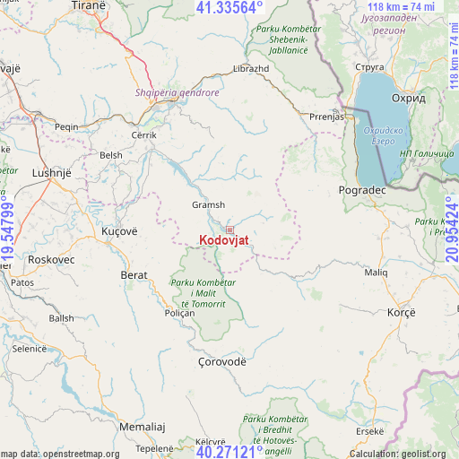
| Upper-left | 41.33564°, | 19.54799° |
| Center: | 40.80556°, | 20.25111° |
| Lower-right: | 40.27121°, | 20.95424° |
| Map W x H: | 118.4×118.4 km | = 73.6×73.6mi |
| max Lat: | 42.45139° ⇑63.7% North |
| Kodovjat: | 40.80556° |
| min Lat: | ⇓36.3% South 39.65889° |
| min Long | Kodovjat | max Long |
| 19.40556° | 20.25111° | 20.99° |
| W 72.1%⇐ | ⇒27.9% E |
Elevation
Elevation of Kodovjat is 276 m = 906 ft, and this is 98.6 m = 323 ft below average elevation for this country.
| Max E: |
1352 m = 4436 ft | 50.4% |
| Avg. | 374.6 m = 1229 ft | |
| Kodovjat | 276 m = 906 ft | |
Min E: |
-2 m = -7 ft | 49.6% |
See also: Albania elevation on elevation.city.
Geographical zone
Kodovjat is located in North temperate zone (between Tropic of Cancer and the Arctic Circle). Distance of this Northern Tropic circle is 1931.2 km =1200 mi to South.| Distance of | km | miles | from Kodovjat |
|---|---|---|---|
| North Pole | 5469.9 | 3398.8 | to North |
| Arctic Circle | 2864 | 1779.6 | to North |
| Tropic Cancer | 1931.2 | 1200 | to South |
| Equator | 4537.2 | 2819.3 | to South |


Nearby cities:
15 places around Kodovjat: (largest is in red/bold)
• Gjerbës
19.6 km =12.2 mi,  180°
180°
• Gramsh
9.1 km =5.7 mi,  321°
321°
• Kukur
11.7 km =7.3 mi,  53°
53°
• Kushovë
5.6 km =3.5 mi,  250°
250°
• Lenias
12.6 km =7.8 mi,  110°
110°
• Moglicë
18.5 km =11.5 mi,  121°
121°
• Pishaj
10.2 km =6.3 mi,  325°
325°
• Poroçan
15.7 km =9.8 mi,  14°
14°
• Roshnik
19.6 km =12.2 mi, 245°
• Skënderbegas
3.4 km =2.1 mi,  195°
195°
• Sult
15.5 km =9.6 mi,  304°
304°
• Tunjë
12.1 km =7.5 mi,  285°
285°
• Velçan
24.3 km =15.1 mi, 46°
• Zavalinë
19.6 km =12.2 mi, 7°
• Zhepë
14.5 km =9 mi,  168°
168°
Sources, notices
• [Note1] Compared only with cities in Albania existing in our database
• [Src1] Map data: © OpenStreetMap contributors (CC-BY-SA)
• [Src2] Other city data from geonames.org with taken over terms of usage.
• [Src3] Geographical zone / Annual Mean Temperature by Robert A. Rohde @ Wikipedia
