Cudhi Zall geodata
Cudhi Zall (Durrës) is a seat of a third-order administrative division; located in Albania in Europe/Tirane (GMT+2) time zone. In our database, there are 71 cities with bigger population. Compared to other cities in Albania, 71.8% of cities are located further ↓South; 61.1% of cities are located further →East and 79.4% of cities have lower elevation than Cudhi Zall. Note1


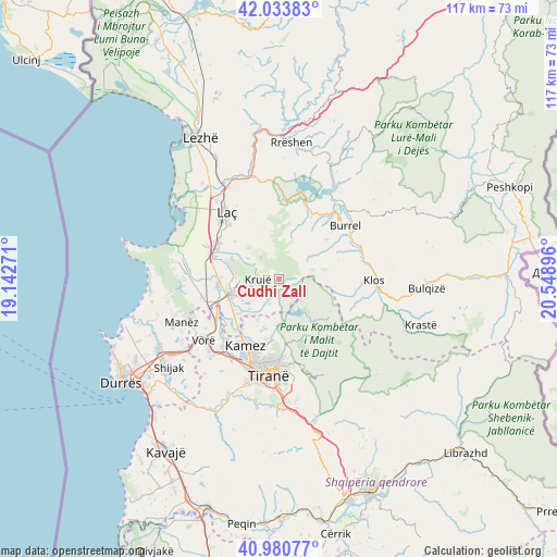
Cudhi Zall GPS coordinates[2]
41° 30' 33.984" North, 19° 50' 44.988" East
| Map corner | latitude | longitude |
|---|---|---|
| Upper-left | 42.03383°, | 19.14271° |
| Center: | 41.50944°, | 19.84583° |
| Lower-right: | 40.98077°, | 20.54896° |
| Map W x H: | 117.1×117.1 km | = 72.8×72.8mi |
| max Lat: | 42.45139° ⇑28.2% North |
| Cudhi Zall: | 41.50944° |
| min Lat: | ⇓71.8% South 39.65889° |
| min Long | Cudhi Zall | max Long |
| 19.40556° | 19.84583° | 20.99° |
| W 38.9%⇐ | ⇒61.1% E |
Elevation
Elevation of Cudhi Zall is 746 m = 2448 ft, and this is 371.4 m = 1219 ft above average elevation for this country.
| Max E: |
1352 m = 4436 ft | 20.6% |
| Cudhi Zall | 746 m 2448 ft | |
| Avg. | 374.6 m = 1229 ft | |
Min E: |
-2 m = -7 ft | 79.4% |
See also: Albania elevation on elevation.city.
Geographical zone
Cudhi Zall is located in North temperate zone (between Tropic of Cancer and the Arctic Circle). Distance of this Northern Tropic circle is 2009.5 km =1248.6 mi to South.| Distance of | km | miles | from Cudhi Zall |
|---|---|---|---|
| North Pole | 5391.6 | 3350.2 | to North |
| Arctic Circle | 2785.8 | 1731 | to North |
| Tropic Cancer | 2009.5 | 1248.6 | to South |
| Equator | 4615.4 | 2867.9 | to South |


Nearby cities:
15 places around Cudhi Zall: (largest is in red/bold)
• Baz
15.3 km =9.5 mi,  26°
26°
• Dajt
14.1 km =8.8 mi,  155°
155°
• Fushë-Krujë
11.2 km =7 mi,  252°
252°
• Gurra e Vogël
12.4 km =7.7 mi,  76°
76°
• Hasan
12.5 km =7.8 mi,  256°
256°
• Kallmet
10.4 km =6.5 mi,  191°
191°
• Kamëz
15.9 km =9.9 mi,  206°
206°
• Kombësi
14.1 km =8.8 mi,  55°
55°
• Krujë
4.4 km =2.7 mi,  269°
269°
• Mamurras
14.9 km =9.3 mi,  300°
300°
• Nikël
10.9 km =6.8 mi,  228°
228°
• Selitë
15.9 km =9.9 mi,  331°
331°
• Thumanë
14.6 km =9.1 mi,  286°
286°
• Zall-Bastar
11.3 km =7 mi,  141°
141°
• Zall-Herr
13.4 km =8.3 mi, 186°
Sources, notices
• [Note1] Compared only with cities in Albania existing in our database
• [Src1] Map data: © OpenStreetMap contributors (CC-BY-SA)
• [Src2] Other city data from geonames.org with taken over terms of usage.
• [Src3] Geographical zone / Annual Mean Temperature by Robert A. Rohde @ Wikipedia
