Luftinjë geodata
Luftinjë (Gjirokastër) is a seat of a third-order administrative division; located in Albania in Europe/Tirane (GMT+2) time zone. In our database, there are 71 cities with bigger population. Compared to other cities in Albania, 85.9% of cities are located further ↑North; 52.4% of cities are located further →East and 62.5% of cities have lower elevation than Luftinjë. Note1


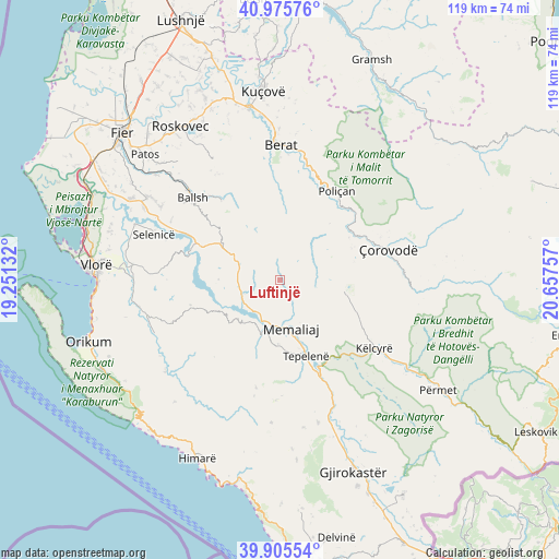
Luftinjë GPS coordinates[2]
40° 26' 34.008" North, 19° 57' 15.984" East
| Map corner | latitude | longitude |
|---|---|---|
| Upper-left | 40.97576°, | 19.25132° |
| Center: | 40.44278°, | 19.95444° |
| Lower-right: | 39.90554°, | 20.65757° |
| Map W x H: | 119×119 km | = 73.9×73.9mi |
| max Lat: | 42.45139° ⇑85.9% North |
| Luftinjë: | 40.44278° |
| min Lat: | ⇓14.1% South 39.65889° |
| min Long | Luftinjë | max Long |
| 19.40556° | 19.95444° | 20.99° |
| W 47.6%⇐ | ⇒52.4% E |
Elevation
Elevation of Luftinjë is 432 m = 1417 ft, and this is 57.4 m = 188 ft above average elevation for this country.
| Max E: |
1352 m = 4436 ft | 37.5% |
| Luftinjë | 432 m 1417 ft | |
| Avg. | 374.6 m = 1229 ft | |
Min E: |
-2 m = -7 ft | 62.5% |
See also: Albania elevation on elevation.city.
Geographical zone
Luftinjë is located in North temperate zone (between Tropic of Cancer and the Arctic Circle). Distance of this Northern Tropic circle is 1890.9 km =1175 mi to South.| Distance of | km | miles | from Luftinjë |
|---|---|---|---|
| North Pole | 5510.2 | 3423.9 | to North |
| Arctic Circle | 2904.4 | 1804.7 | to North |
| Tropic Cancer | 1890.9 | 1175 | to South |
| Equator | 4496.8 | 2794.2 | to South |


Nearby cities:
15 places around Luftinjë: (largest is in red/bold)
• Aranitas
21 km =13 mi,  323°
323°
• Ballaban
15.5 km =9.6 mi,  100°
100°
• Bogovë
21.8 km =13.5 mi,  49°
49°
• Buz
4.3 km =2.7 mi,  86°
86°
• Fratar
13.3 km =8.3 mi,  298°
298°
• Greshicë
19.2 km =11.9 mi,  309°
309°
• Kalenjë
22.1 km =13.7 mi, 317°
• Krahës
9.3 km =5.8 mi,  267°
267°
• Kutë
16.3 km =10.1 mi,  282°
282°
• Memaliaj
10.4 km =6.5 mi,  167°
167°
• Selitë
14.7 km =9.1 mi, 322°
• Sevaster
19.7 km =12.2 mi,  254°
254°
• Sukë
18.5 km =11.5 mi,  113°
113°
• Tepelenë
17.2 km =10.7 mi,  161°
161°
• Vendresha e Vogël
16.8 km =10.4 mi,  64°
64°
Sources, notices
• [Note1] Compared only with cities in Albania existing in our database
• [Src1] Map data: © OpenStreetMap contributors (CC-BY-SA)
• [Src2] Other city data from geonames.org with taken over terms of usage.
• [Src3] Geographical zone / Annual Mean Temperature by Robert A. Rohde @ Wikipedia
