Kapan geodata
Kapan (Syunik) is a seat of a first-order administrative division; located in Armenia in Asia/Yerevan (GMT+4) time zone. With population of 33,160 people, there are 6 cities with bigger population in this country. Compared to other cities in Armenia, 99.4% of cities are located further ↑North; 99% of cities are located further ←West and 96.5% of cities have higher elevation than Kapan. Note1


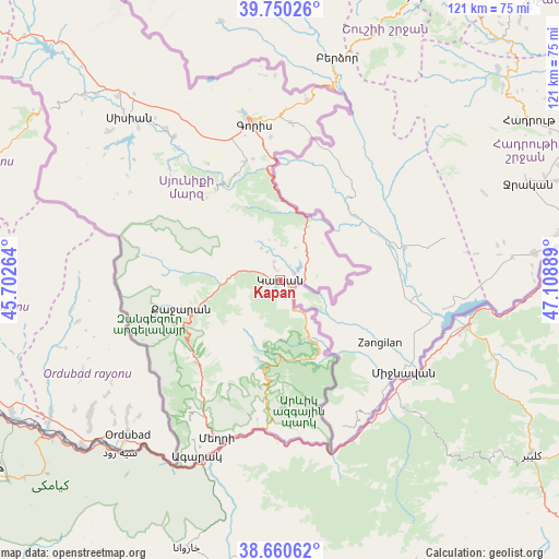
Kapan GPS coordinates[2]
39° 12' 27.18" North, 46° 24' 20.736" East
| Map corner | latitude | longitude |
|---|---|---|
| Upper-left | 39.75026°, | 45.70264° |
| Center: | 39.20755°, | 46.40576° |
| Lower-right: | 38.66062°, | 47.10889° |
| Map W x H: | 121.2×121.2 km | = 75.3×75.3mi |
| max Lat: | 41.24358° ⇑99.4% North |
| Kapan: | 39.20755° |
| min Lat: | ⇓0.6% South 38.90292° |
| min Long | Kapan | max Long |
| 43.74722° | 46.40576° | 46.5446° |
| W 99%⇐ | ⇒1% E |
Elevation
Elevation of Kapan is 774 m = 2539 ft, and this is 527.5 m = 1731 ft below average elevation for this country.
| Max E: |
2169 m = 7116 ft | 96.5% |
| Avg. | 1301.5 m = 4270 ft | |
| Kapan | 774 m = 2539 ft | |
Min E: |
440 m = 1444 ft | 3.5% |
See also: Armenia elevation on elevation.city.
Geographical zone
Kapan is located in North temperate zone (between Tropic of Cancer and the Arctic Circle). Distance of this Northern Tropic circle is 1753.6 km =1089.6 mi to South.| Distance of | km | miles | from Kapan |
|---|---|---|---|
| North Pole | 5647.6 | 3509.3 | to North |
| Arctic Circle | 3041.7 | 1890 | to North |
| Tropic Cancer | 1753.6 | 1089.6 | to South |
| Equator | 4359.5 | 2708.9 | to South |


Nearby cities:
15 places around Kapan: (largest is in red/bold)
• Agarak
12 km =7.5 mi,  90°
90°
• Akner
37.4 km =23.2 mi,  346°
346°
• Angeghakot’
56.5 km =35.1 mi,  315°
315°
• Brrnakot’
49.3 km =30.6 mi,  310°
310°
• Dzorastan
8.2 km =5.1 mi,  329°
329°
• Gorayk’
76.4 km =47.5 mi, 313°
• Goris
34.2 km =21.3 mi, 350°
• Hats’avan
47.1 km =29.3 mi, 307°
• Khndzoresk
33.3 km =20.7 mi,  4°
4°
• Meghri
36.6 km =22.7 mi,  202°
202°
• Shaghat
57.8 km =35.9 mi, 312°
• Shinuhayr
26.6 km =16.5 mi,  343°
343°
• Tat’ev
24.2 km =15 mi, 325°
• Tegh
39.5 km =24.5 mi,  9°
9°
• Verishen
37.2 km =23.1 mi, 348°
Sources, notices
• [Note1] Compared only with cities in Armenia existing in our database
• [Src1] Map data: © OpenStreetMap contributors (CC-BY-SA)
• [Src2] Other city data from geonames.org with taken over terms of usage.
• [Src3] Geographical zone / Annual Mean Temperature by Robert A. Rohde @ Wikipedia
