Agarak geodata
Agarak (Syunik) is a populated place; located in Armenia in Asia/Yerevan (GMT+4) time zone. With population of 4,707 people, there are 48 cities with bigger population in this country. Compared to other cities in Armenia, 99.7% of cities are located further ↑North; 100% of cities are located further ←West and 59.2% of cities have higher elevation than Agarak. Note1


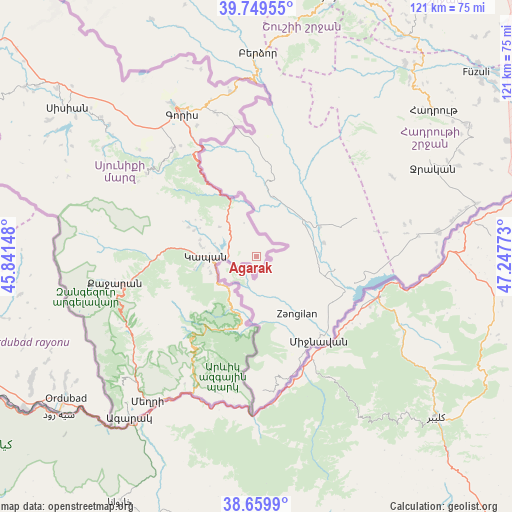
Agarak GPS coordinates[2]
39° 12' 24.624" North, 46° 32' 40.56" East
| Map corner | latitude | longitude |
|---|---|---|
| Upper-left | 39.74955°, | 45.84148° |
| Center: | 39.20684°, | 46.5446° |
| Lower-right: | 38.6599°, | 47.24773° |
| Map W x H: | 121.2×121.2 km | = 75.3×75.3mi |
| max Lat: | 41.24358° ⇑99.7% North |
| Agarak: | 39.20684° |
| min Lat: | ⇓0.3% South 38.90292° |
| min Long | Agarak | max Long |
| 43.74722° | 46.5446° | 46.5446° |
| W 100%⇐ | ⇒0% E |
Elevation
Elevation of Agarak is 998 m = 3274 ft, and this is 303.5 m = 996 ft below average elevation for this country.
| Max E: |
2169 m = 7116 ft | 59.2% |
| Avg. | 1301.5 m = 4270 ft | |
| Agarak | 998 m = 3274 ft | |
Min E: |
440 m = 1444 ft | 40.8% |
See also: Armenia elevation on elevation.city.
Geographical zone
Agarak is located in North temperate zone (between Tropic of Cancer and the Arctic Circle). Distance of this Northern Tropic circle is 1753.5 km =1089.6 mi to South.| Distance of | km | miles | from Agarak |
|---|---|---|---|
| North Pole | 5647.7 | 3509.3 | to North |
| Arctic Circle | 3041.8 | 1890.1 | to North |
| Tropic Cancer | 1753.5 | 1089.6 | to South |
| Equator | 4359.4 | 2708.8 | to South |


Nearby cities:
15 places around Agarak: (largest is in red/bold)
• Akner
41.8 km =26 mi,  330°
330°
• Angeghakot’
65.5 km =40.7 mi,  308°
308°
• Brrnakot’
58.9 km =36.6 mi,  303°
303°
• Dzorastan
17.6 km =10.9 mi,  293°
293°
• Gorayk’
85.5 km =53.1 mi, 308°
• Goris
38.1 km =23.7 mi, 332°
• Hats’avan
57.1 km =35.5 mi, 300°
• Kapan
12 km =7.5 mi,  270°
270°
• Khndzoresk
34.5 km =21.4 mi,  344°
344°
• Meghri
42.6 km =26.5 mi,  217°
217°
• Shaghat
67.2 km =41.8 mi, 305°
• Shinuhayr
32.1 km =19.9 mi,  322°
322°
• Tat’ev
32.6 km =20.3 mi, 307°
• Tegh
39.5 km =24.5 mi,  351°
351°
• Verishen
41.3 km =25.7 mi, 332°
Sources, notices
• [Note1] Compared only with cities in Armenia existing in our database
• [Src1] Map data: © OpenStreetMap contributors (CC-BY-SA)
• [Src2] Other city data from geonames.org with taken over terms of usage.
• [Src3] Geographical zone / Annual Mean Temperature by Robert A. Rohde @ Wikipedia
