Tandzut geodata
Tandzut (Armavir) is a populated place; located in Armenia in Asia/Yerevan (GMT+4) time zone. With population of 1,816 people, there are 179 cities with bigger population in this country. Compared to other cities in Armenia, 73.2% of cities are located further ↑North; 85.7% of cities are located further →East and 79.3% of cities have higher elevation than Tandzut. Note1


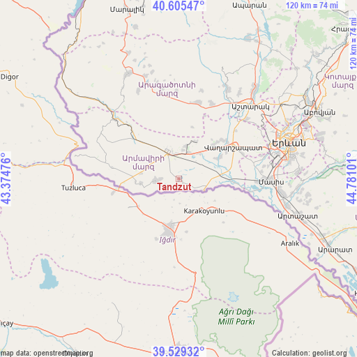
Tandzut GPS coordinates[2]
40° 4' 10.272" North, 44° 4' 40.368" East
| Map corner | latitude | longitude |
|---|---|---|
| Upper-left | 40.60547°, | 43.37476° |
| Center: | 40.06952°, | 44.07788° |
| Lower-right: | 39.52932°, | 44.78101° |
| Map W x H: | 119.7×119.7 km | = 74.4×74.4mi |
| max Lat: | 41.24358° ⇑73.2% North |
| Tandzut: | 40.06952° |
| min Lat: | ⇓26.8% South 38.90292° |
| min Long | Tandzut | max Long |
| 43.74722° | 44.07788° | 46.5446° |
| W 14.3%⇐ | ⇒85.7% E |
Elevation
Elevation of Tandzut is 854 m = 2802 ft, and this is 447.5 m = 1468 ft below average elevation for this country.
| Max E: |
2169 m = 7116 ft | 79.3% |
| Avg. | 1301.5 m = 4270 ft | |
| Tandzut | 854 m = 2802 ft | |
Min E: |
440 m = 1444 ft | 20.7% |
See also: Armenia elevation on elevation.city.
Geographical zone
Tandzut is located in North temperate zone (between Tropic of Cancer and the Arctic Circle). Distance of this Northern Tropic circle is 1849.4 km =1149.2 mi to South.| Distance of | km | miles | from Tandzut |
|---|---|---|---|
| North Pole | 5551.7 | 3449.7 | to North |
| Arctic Circle | 2945.9 | 1830.5 | to North |
| Tropic Cancer | 1849.4 | 1149.2 | to South |
| Equator | 4455.3 | 2768.4 | to South |


Nearby cities:
15 places around Tandzut: (largest is in red/bold)
• Alashkert
4.8 km =3 mi,  331°
331°
• Arazap’
6.7 km =4.2 mi,  117°
117°
• Arevik
3.7 km =2.3 mi,  22°
22°
• Argavand
1.7 km =1.1 mi, 123°
• Aygeshat
1.6 km =1 mi,  293°
293°
• Bambakashat
6.6 km =4.1 mi,  310°
310°
• Janfida
5.1 km =3.2 mi,  236°
236°
• Margara
9.6 km =6 mi,  114°
114°
• Metsamor
9 km =5.6 mi, 21°
• Mrgashat
6.8 km =4.2 mi,  2°
2°
• Nalbandyan
7.6 km =4.7 mi,  265°
265°
• Nor Armavir
7.3 km =4.5 mi,  284°
284°
• P’shatavan
3.5 km =2.2 mi,  195°
195°
• Sardarapat
9.1 km =5.7 mi,  320°
320°
• Yeghegnut
7.9 km =4.9 mi,  74°
74°
Sources, notices
• [Note1] Compared only with cities in Armenia existing in our database
• [Src1] Map data: © OpenStreetMap contributors (CC-BY-SA)
• [Src2] Other city data from geonames.org with taken over terms of usage.
• [Src3] Geographical zone / Annual Mean Temperature by Robert A. Rohde @ Wikipedia
