Yeghegnut geodata
Yeghegnut (Armavir) is a populated place; located in Armenia in Asia/Yerevan (GMT+4) time zone. With population of 1,746 people, there are 188 cities with bigger population in this country. Compared to other cities in Armenia, 70.1% of cities are located further ↑North; 81.5% of cities are located further →East and 82.2% of cities have higher elevation than Yeghegnut. Note1


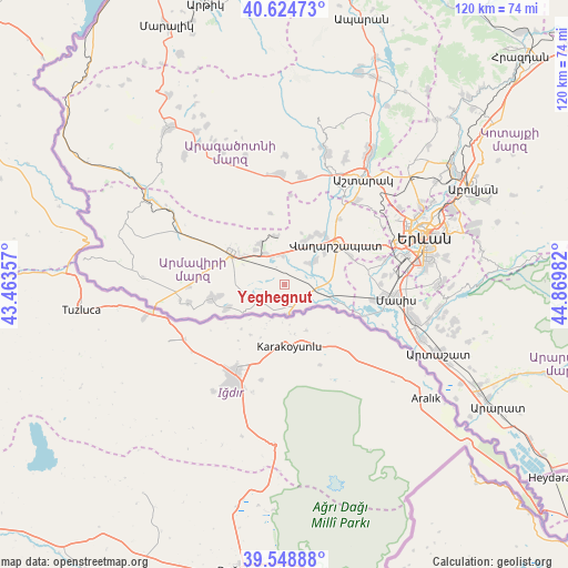
Yeghegnut GPS coordinates[2]
40° 5' 20.148" North, 44° 10' 0.084" East
| Map corner | latitude | longitude |
|---|---|---|
| Upper-left | 40.62473°, | 43.46357° |
| Center: | 40.08893°, | 44.16669° |
| Lower-right: | 39.54888°, | 44.86982° |
| Map W x H: | 119.6×119.6 km | = 74.3×74.3mi |
| max Lat: | 41.24358° ⇑70.1% North |
| Yeghegnut: | 40.08893° |
| min Lat: | ⇓29.9% South 38.90292° |
| min Long | Yeghegnut | max Long |
| 43.74722° | 44.16669° | 46.5446° |
| W 18.5%⇐ | ⇒81.5% E |
Elevation
Elevation of Yeghegnut is 847 m = 2779 ft, and this is 454.5 m = 1491 ft below average elevation for this country.
| Max E: |
2169 m = 7116 ft | 82.2% |
| Avg. | 1301.5 m = 4270 ft | |
| Yeghegnut | 847 m = 2779 ft | |
Min E: |
440 m = 1444 ft | 17.8% |
See also: Armenia elevation on elevation.city.
Geographical zone
Yeghegnut is located in North temperate zone (between Tropic of Cancer and the Arctic Circle). Distance of this Northern Tropic circle is 1851.6 km =1150.5 mi to South.| Distance of | km | miles | from Yeghegnut |
|---|---|---|---|
| North Pole | 5549.6 | 3448.4 | to North |
| Arctic Circle | 2943.7 | 1829.1 | to North |
| Tropic Cancer | 1851.6 | 1150.5 | to South |
| Equator | 4457.5 | 2769.8 | to South |


Nearby cities:
15 places around Yeghegnut: (largest is in red/bold)
• Aknalich
6.5 km =4 mi,  0°
0°
• Apaga
7.4 km =4.6 mi,  82°
82°
• Arazap’
5.5 km =3.4 mi,  197°
197°
• Arevik
6.3 km =3.9 mi,  281°
281°
• Argavand
6.9 km =4.3 mi,  243°
243°
• Arshaluys
9.8 km =6.1 mi,  24°
24°
• Aygeshat
9.1 km =5.7 mi,  260°
260°
• Griboyedov
9.3 km =5.8 mi,  73°
73°
• Khoronk’
8.6 km =5.3 mi,  52°
52°
• Margara
6.3 km =3.9 mi,  169°
169°
• Metsamor
7.5 km =4.7 mi,  325°
325°
• Mrgashat
8.7 km =5.4 mi,  302°
302°
• Tandzut
7.9 km =4.9 mi,  254°
254°
• Taronik
5.7 km =3.5 mi,  29°
29°
• Yeraskhahun
4.9 km =3 mi,  112°
112°
Sources, notices
• [Note1] Compared only with cities in Armenia existing in our database
• [Src1] Map data: © OpenStreetMap contributors (CC-BY-SA)
• [Src2] Other city data from geonames.org with taken over terms of usage.
• [Src3] Geographical zone / Annual Mean Temperature by Robert A. Rohde @ Wikipedia
