Arevik geodata
Arevik (Armavir) is a populated place; located in Armenia in Asia/Yerevan (GMT+4) time zone. With population of 2,455 people, there are 118 cities with bigger population in this country. Compared to other cities in Armenia, 68.2% of cities are located further ↑North; 84.7% of cities are located further →East and 79.9% of cities have higher elevation than Arevik. Note1


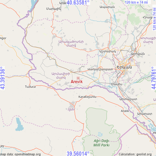
Arevik GPS coordinates[2]
40° 6' 0.36" North, 44° 5' 40.128" East
| Map corner | latitude | longitude |
|---|---|---|
| Upper-left | 40.63581°, | 43.39136° |
| Center: | 40.1001°, | 44.09448° |
| Lower-right: | 39.56014°, | 44.79761° |
| Map W x H: | 119.6×119.6 km | = 74.3×74.3mi |
| max Lat: | 41.24358° ⇑68.2% North |
| Arevik: | 40.1001° |
| min Lat: | ⇓31.8% South 38.90292° |
| min Long | Arevik | max Long |
| 43.74722° | 44.09448° | 46.5446° |
| W 15.3%⇐ | ⇒84.7% E |
Elevation
Elevation of Arevik is 853 m = 2799 ft, and this is 448.5 m = 1471 ft below average elevation for this country.
| Max E: |
2169 m = 7116 ft | 79.9% |
| Avg. | 1301.5 m = 4270 ft | |
| Arevik | 853 m = 2799 ft | |
Min E: |
440 m = 1444 ft | 20.1% |
See also: Armenia elevation on elevation.city.
Geographical zone
Arevik is located in North temperate zone (between Tropic of Cancer and the Arctic Circle). Distance of this Northern Tropic circle is 1852.8 km =1151.3 mi to South.| Distance of | km | miles | from Arevik |
|---|---|---|---|
| North Pole | 5548.3 | 3447.6 | to North |
| Arctic Circle | 2942.5 | 1828.4 | to North |
| Tropic Cancer | 1852.8 | 1151.3 | to South |
| Equator | 4458.7 | 2770.5 | to South |


Nearby cities:
15 places around Arevik: (largest is in red/bold)
• Aknalich
8.1 km =5 mi,  49°
49°
• Alashkert
3.8 km =2.4 mi,  281°
281°
• Arazap’
7.9 km =4.9 mi,  145°
145°
• Argavand
4.3 km =2.7 mi,  180°
180°
• Armavir
7.7 km =4.8 mi,  321°
321°
• Aygeshat
4 km =2.5 mi,  225°
225°
• Bambakashat
6.4 km =4 mi, 278°
• Janfida
8.4 km =5.2 mi,  222°
222°
• Mayisyan
6.3 km =3.9 mi,  358°
358°
• Metsamor
5.3 km =3.3 mi,  20°
20°
• Mrgashat
3.6 km =2.2 mi,  340°
340°
• P’shatavan
7.2 km =4.5 mi,  199°
199°
• Sardarapat
8 km =5 mi,  296°
296°
• Tandzut
3.7 km =2.3 mi, 202°
• Yeghegnut
6.3 km =3.9 mi,  101°
101°
Sources, notices
• [Note1] Compared only with cities in Armenia existing in our database
• [Src1] Map data: © OpenStreetMap contributors (CC-BY-SA)
• [Src2] Other city data from geonames.org with taken over terms of usage.
• [Src3] Geographical zone / Annual Mean Temperature by Robert A. Rohde @ Wikipedia
