Fantan geodata
Fantan (Kotayk) is a populated place; located in Armenia in Asia/Yerevan (GMT+4) time zone. With population of 1,019 people, there are 304 cities with bigger population in this country. Compared to other cities in Armenia, 64.6% of cities are located further ↓South; 65.6% of cities are located further ←West and 81.8% of cities have lower elevation than Fantan. Note1


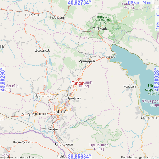
Fantan GPS coordinates[2]
40° 23' 40.092" North, 44° 41' 9.96" East
| Map corner | latitude | longitude |
|---|---|---|
| Upper-left | 40.92784°, | 43.98298° |
| Center: | 40.39447°, | 44.6861° |
| Lower-right: | 39.85684°, | 45.38923° |
| Map W x H: | 119.1×119.1 km | = 74×74mi |
| max Lat: | 41.24358° ⇑35.4% North |
| Fantan: | 40.39447° |
| min Lat: | ⇓64.6% South 38.90292° |
| min Long | Fantan | max Long |
| 43.74722° | 44.6861° | 46.5446° |
| W 65.6%⇐ | ⇒34.4% E |
Elevation
Elevation of Fantan is 1801 m = 5909 ft, and this is 499.5 m = 1639 ft above average elevation for this country.
| Max E: |
2169 m = 7116 ft | 18.2% |
| Fantan | 1801 m 5909 ft | |
| Avg. | 1301.5 m = 4270 ft | |
Min E: |
440 m = 1444 ft | 81.8% |
See also: Armenia elevation on elevation.city.
Geographical zone
Fantan is located in North temperate zone (between Tropic of Cancer and the Arctic Circle). Distance of this Northern Tropic circle is 1885.5 km =1171.6 mi to South.| Distance of | km | miles | from Fantan |
|---|---|---|---|
| North Pole | 5515.6 | 3427.2 | to North |
| Arctic Circle | 2909.7 | 1808 | to North |
| Tropic Cancer | 1885.5 | 1171.6 | to South |
| Equator | 4491.4 | 2790.8 | to South |


Nearby cities:
15 places around Fantan: (largest is in red/bold)
• Abovyan
14.2 km =8.8 mi,  198°
198°
• Akunk’
14.2 km =8.8 mi,  180°
180°
• Aragyugh
12 km =7.5 mi,  274°
274°
• Argel
7.5 km =4.7 mi,  255°
255°
• Arzakan
9 km =5.6 mi,  313°
313°
• Arzni
13.1 km =8.1 mi,  214°
214°
• Bjni
7.7 km =4.8 mi,  336°
336°
• Byureghavan
11.9 km =7.4 mi,  221°
221°
• Hrazdan
13.3 km =8.3 mi,  30°
30°
• Kaputan
7.8 km =4.8 mi,  171°
171°
• Kotayk’
13.1 km =8.1 mi,  188°
188°
• Lerrnanist
12.1 km =7.5 mi,  48°
48°
• Nor Geghi
11.8 km =7.3 mi,  227°
227°
• Nor Gyugh
14.4 km =8.9 mi, 189°
• Solak
7.8 km =4.8 mi,  13°
13°
Sources, notices
• [Note1] Compared only with cities in Armenia existing in our database
• [Src1] Map data: © OpenStreetMap contributors (CC-BY-SA)
• [Src2] Other city data from geonames.org with taken over terms of usage.
• [Src3] Geographical zone / Annual Mean Temperature by Robert A. Rohde @ Wikipedia
