Zoravan geodata
Zoravan (Kotayk) is a populated place; located in Armenia in Asia/Yerevan (GMT+4) time zone. With population of 1,167 people, there are 272 cities with bigger population in this country. Compared to other cities in Armenia, 63.4% of cities are located further ↓South; 51.3% of cities are located further →East and 60.8% of cities have lower elevation than Zoravan. Note1


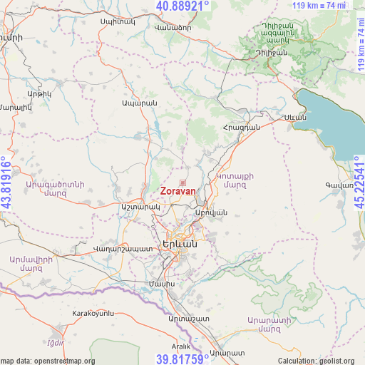
Zoravan GPS coordinates[2]
40° 21' 19.908" North, 44° 31' 20.208" East
| Map corner | latitude | longitude |
|---|---|---|
| Upper-left | 40.88921°, | 43.81916° |
| Center: | 40.35553°, | 44.52228° |
| Lower-right: | 39.81759°, | 45.22541° |
| Map W x H: | 119.2×119.2 km | = 74.1×74.1mi |
| max Lat: | 41.24358° ⇑36.6% North |
| Zoravan: | 40.35553° |
| min Lat: | ⇓63.4% South 38.90292° |
| min Long | Zoravan | max Long |
| 43.74722° | 44.52228° | 46.5446° |
| W 48.7%⇐ | ⇒51.3% E |
Elevation
Elevation of Zoravan is 1469 m = 4820 ft, and this is 167.5 m = 550 ft above average elevation for this country.
| Max E: |
2169 m = 7116 ft | 39.2% |
| Zoravan | 1469 m 4820 ft | |
| Avg. | 1301.5 m = 4270 ft | |
Min E: |
440 m = 1444 ft | 60.8% |
See also: Armenia elevation on elevation.city.
Geographical zone
Zoravan is located in North temperate zone (between Tropic of Cancer and the Arctic Circle). Distance of this Northern Tropic circle is 1881.2 km =1168.9 mi to South.| Distance of | km | miles | from Zoravan |
|---|---|---|---|
| North Pole | 5519.9 | 3429.9 | to North |
| Arctic Circle | 2914.1 | 1810.7 | to North |
| Tropic Cancer | 1881.2 | 1168.9 | to South |
| Equator | 4487.1 | 2788.2 | to South |


Nearby cities:
15 places around Zoravan: (largest is in red/bold)
• Abovyan
13.1 km =8.1 mi,  133°
133°
• Aragyugh
5.6 km =3.5 mi,  19°
19°
• Argel
7 km =4.3 mi,  69°
69°
• Arzakan
12.8 km =8 mi,  34°
34°
• Arzni
9.2 km =5.7 mi, 134°
• Buzhakan
11.1 km =6.9 mi,  358°
358°
• Byureghavan
7.6 km =4.7 mi, 127°
• Karbi
12.5 km =7.8 mi,  257°
257°
• K’anak’erravan
12.1 km =7.5 mi,  174°
174°
• Mrgashen
7.9 km =4.9 mi, 166°
• Nor Geghi
6.4 km =4 mi, 125°
• Nor Yerznka
12.9 km =8 mi,  241°
241°
• Ptghni
12.4 km =7.7 mi,  154°
154°
• Ushi
12.5 km =7.8 mi,  265°
265°
• Yeghvard
4.6 km =2.9 mi,  222°
222°
Sources, notices
• [Note1] Compared only with cities in Armenia existing in our database
• [Src1] Map data: © OpenStreetMap contributors (CC-BY-SA)
• [Src2] Other city data from geonames.org with taken over terms of usage.
• [Src3] Geographical zone / Annual Mean Temperature by Robert A. Rohde @ Wikipedia
