Sasunik geodata
Sasunik (Aragatsotn) is a populated place; located in Armenia in Asia/Yerevan (GMT+4) time zone. With population of 1,959 people, there are 160 cities with bigger population in this country. Compared to other cities in Armenia, 53.2% of cities are located further ↓South; 69.1% of cities are located further →East and 57.6% of cities have higher elevation than Sasunik. Note1


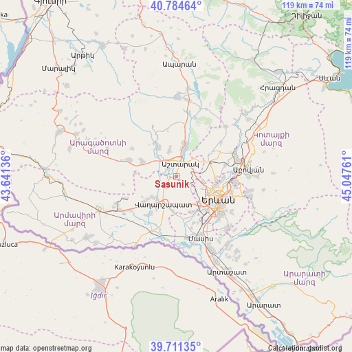
Sasunik GPS coordinates[2]
40° 15' 0.432" North, 44° 20' 40.128" East
| Map corner | latitude | longitude |
|---|---|---|
| Upper-left | 40.78464°, | 43.64136° |
| Center: | 40.25012°, | 44.34448° |
| Lower-right: | 39.71135°, | 45.04761° |
| Map W x H: | 119.3×119.3 km | = 74.1×74.1mi |
| max Lat: | 41.24358° ⇑46.8% North |
| Sasunik: | 40.25012° |
| min Lat: | ⇓53.2% South 38.90292° |
| min Long | Sasunik | max Long |
| 43.74722° | 44.34448° | 46.5446° |
| W 30.9%⇐ | ⇒69.1% E |
Elevation
Elevation of Sasunik is 1071 m = 3514 ft, and this is 230.5 m = 756 ft below average elevation for this country.
| Max E: |
2169 m = 7116 ft | 57.6% |
| Avg. | 1301.5 m = 4270 ft | |
| Sasunik | 1071 m = 3514 ft | |
Min E: |
440 m = 1444 ft | 42.4% |
See also: Armenia elevation on elevation.city.
Geographical zone
Sasunik is located in North temperate zone (between Tropic of Cancer and the Arctic Circle). Distance of this Northern Tropic circle is 1869.5 km =1161.7 mi to South.| Distance of | km | miles | from Sasunik |
|---|---|---|---|
| North Pole | 5531.7 | 3437.2 | to North |
| Arctic Circle | 2925.8 | 1818 | to North |
| Tropic Cancer | 1869.5 | 1161.7 | to South |
| Equator | 4475.4 | 2780.9 | to South |


Nearby cities:
15 places around Sasunik: (largest is in red/bold)
• Aghavnatun
8 km =5 mi,  256°
256°
• Ashtarak
5.6 km =3.5 mi,  15°
15°
• Aygek
7.7 km =4.8 mi,  152°
152°
• Aygeshat
5 km =3.1 mi,  251°
251°
• Baghramyan
6.5 km =4 mi,  161°
161°
• Doghs
6.9 km =4.3 mi,  243°
243°
• Gmbet’
8.2 km =5.1 mi, 249°
• Karbi
9.4 km =5.8 mi, 17°
• Merdzavan
9 km =5.6 mi, 148°
• Nor Yerznka
6.7 km =4.2 mi,  34°
34°
• Norakert
5.9 km =3.7 mi,  175°
175°
• Oshakan
2.8 km =1.7 mi,  303°
303°
• Prroshyan
6.4 km =4 mi,  92°
92°
• Tsiatsan
9.6 km =6 mi,  221°
221°
• Voskevaz
4.7 km =2.9 mi,  306°
306°
Sources, notices
• [Note1] Compared only with cities in Armenia existing in our database
• [Src1] Map data: © OpenStreetMap contributors (CC-BY-SA)
• [Src2] Other city data from geonames.org with taken over terms of usage.
• [Src3] Geographical zone / Annual Mean Temperature by Robert A. Rohde @ Wikipedia
