Karbi geodata
Karbi (Aragatsotn) is a populated place; located in Armenia in Asia/Yerevan (GMT+4) time zone. With population of 3,521 people, there are 75 cities with bigger population in this country. Compared to other cities in Armenia, 61.5% of cities are located further ↓South; 65.6% of cities are located further →East and 50.3% of cities have higher elevation than Karbi. Note1


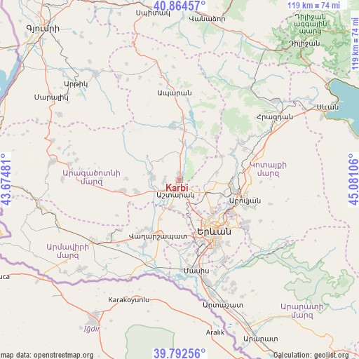
Karbi GPS coordinates[2]
40° 19' 50.484" North, 44° 22' 40.548" East
| Map corner | latitude | longitude |
|---|---|---|
| Upper-left | 40.86457°, | 43.67481° |
| Center: | 40.33069°, | 44.37793° |
| Lower-right: | 39.79256°, | 45.08106° |
| Map W x H: | 119.2×119.2 km | = 74.1×74.1mi |
| max Lat: | 41.24358° ⇑38.5% North |
| Karbi: | 40.33069° |
| min Lat: | ⇓61.5% South 38.90292° |
| min Long | Karbi | max Long |
| 43.74722° | 44.37793° | 46.5446° |
| W 34.4%⇐ | ⇒65.6% E |
Elevation
Elevation of Karbi is 1305 m = 4281 ft, and this is 3.5 m = 11 ft above average elevation for this country.
| Max E: |
2169 m = 7116 ft | 50.3% |
| Karbi | 1305 m 4281 ft | |
| Avg. | 1301.5 m = 4270 ft | |
Min E: |
440 m = 1444 ft | 49.7% |
See also: Armenia elevation on elevation.city.
Geographical zone
Karbi is located in North temperate zone (between Tropic of Cancer and the Arctic Circle). Distance of this Northern Tropic circle is 1878.4 km =1167.2 mi to South.| Distance of | km | miles | from Karbi |
|---|---|---|---|
| North Pole | 5522.7 | 3431.6 | to North |
| Arctic Circle | 2916.8 | 1812.4 | to North |
| Tropic Cancer | 1878.4 | 1167.2 | to South |
| Equator | 4484.4 | 2786.5 | to South |


Nearby cities:
15 places around Karbi: (largest is in red/bold)
• Ashtarak
3.8 km =2.4 mi,  200°
200°
• Aygeshat
13 km =8.1 mi,  215°
215°
• Baghramyan
15.2 km =9.4 mi,  182°
182°
• Byurakan
9 km =5.6 mi,  275°
275°
• Doghs
15 km =9.3 mi, 216°
• Mrgashen
15 km =9.3 mi,  109°
109°
• Nor Yerznka
3.5 km =2.2 mi,  164°
164°
• Norakert
15 km =9.3 mi,  189°
189°
• Oshakan
9.1 km =5.7 mi,  214°
214°
• Prroshyan
9.9 km =6.2 mi, 159°
• Sasunik
9.4 km =5.8 mi, 197°
• Ushi
1.9 km =1.2 mi,  352°
352°
• Voskevaz
9 km =5.6 mi,  226°
226°
• Yeghvard
9.2 km =5.7 mi,  93°
93°
• Zoravan
12.5 km =7.8 mi,  77°
77°
Sources, notices
• [Note1] Compared only with cities in Armenia existing in our database
• [Src1] Map data: © OpenStreetMap contributors (CC-BY-SA)
• [Src2] Other city data from geonames.org with taken over terms of usage.
• [Src3] Geographical zone / Annual Mean Temperature by Robert A. Rohde @ Wikipedia
