Baghramyan geodata
Baghramyan (Armavir) is a populated place; located in Armenia in Asia/Yerevan (GMT+4) time zone. With population of 2,346 people, there are 125 cities with bigger population in this country. Compared to other cities in Armenia, 50.6% of cities are located further ↑North; 66.9% of cities are located further →East and 61.1% of cities have higher elevation than Baghramyan. Note1


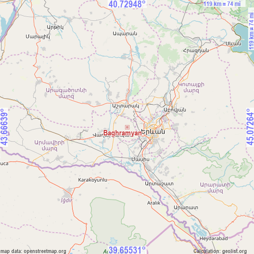
Baghramyan GPS coordinates[2]
40° 11' 40.272" North, 44° 22' 10.236" East
| Map corner | latitude | longitude |
|---|---|---|
| Upper-left | 40.72948°, | 43.66639° |
| Center: | 40.19452°, | 44.36951° |
| Lower-right: | 39.65531°, | 45.07264° |
| Map W x H: | 119.4×119.4 km | = 74.2×74.2mi |
| max Lat: | 41.24358° ⇑50.6% North |
| Baghramyan: | 40.19452° |
| min Lat: | ⇓49.4% South 38.90292° |
| min Long | Baghramyan | max Long |
| 43.74722° | 44.36951° | 46.5446° |
| W 33.1%⇐ | ⇒66.9% E |
Elevation
Elevation of Baghramyan is 947 m = 3107 ft, and this is 354.5 m = 1163 ft below average elevation for this country.
| Max E: |
2169 m = 7116 ft | 61.1% |
| Avg. | 1301.5 m = 4270 ft | |
| Baghramyan | 947 m = 3107 ft | |
Min E: |
440 m = 1444 ft | 38.9% |
See also: Armenia elevation on elevation.city.
Geographical zone
Baghramyan is located in North temperate zone (between Tropic of Cancer and the Arctic Circle). Distance of this Northern Tropic circle is 1863.3 km =1157.8 mi to South.| Distance of | km | miles | from Baghramyan |
|---|---|---|---|
| North Pole | 5537.9 | 3441.1 | to North |
| Arctic Circle | 2932 | 1821.9 | to North |
| Tropic Cancer | 1863.3 | 1157.8 | to South |
| Equator | 4469.2 | 2777 | to South |


Nearby cities:
15 places around Baghramyan: (largest is in red/bold)
• Arbat’
6.8 km =4.2 mi,  155°
155°
• Arevashat
5.6 km =3.5 mi,  175°
175°
• Argavand
7.5 km =4.7 mi,  128°
128°
• Aygek
1.5 km =0.9 mi,  113°
113°
• Aygeshat
8.3 km =5.2 mi,  304°
304°
• Geghanist
7.5 km =4.7 mi,  136°
136°
• Hayanist
8.1 km =5 mi,  174°
174°
• Merdzavan
3 km =1.9 mi,  119°
119°
• Musalerr
4.4 km =2.7 mi, 170°
• Norakert
1.7 km =1.1 mi,  280°
280°
• Prroshyan
7.2 km =4.5 mi,  35°
35°
• Ptghunk’
3.4 km =2.1 mi,  187°
187°
• Sasunik
6.5 km =4 mi,  341°
341°
• Vagharshapat
7.1 km =4.4 mi,  243°
243°
• Voskehat
6.7 km =4.2 mi,  209°
209°
Sources, notices
• [Note1] Compared only with cities in Armenia existing in our database
• [Src1] Map data: © OpenStreetMap contributors (CC-BY-SA)
• [Src2] Other city data from geonames.org with taken over terms of usage.
• [Src3] Geographical zone / Annual Mean Temperature by Robert A. Rohde @ Wikipedia
