Ashtarak geodata
Ashtarak (Aragatsotn) is a seat of a first-order administrative division; located in Armenia in Asia/Yerevan (GMT+4) time zone. With population of 18,779 people, there are 14 cities with bigger population in this country. Compared to other cities in Armenia, 58.6% of cities are located further ↓South; 67.5% of cities are located further →East and 55.7% of cities have higher elevation than Ashtarak. Note1


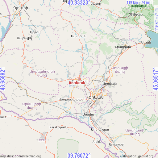
Ashtarak GPS coordinates[2]
40° 17' 56.76" North, 44° 21' 43.344" East
| Map corner | latitude | longitude |
|---|---|---|
| Upper-left | 40.83323°, | 43.65892° |
| Center: | 40.2991°, | 44.36204° |
| Lower-right: | 39.76072°, | 45.06517° |
| Map W x H: | 119.3×119.3 km | = 74.1×74.1mi |
| max Lat: | 41.24358° ⇑41.4% North |
| Ashtarak: | 40.2991° |
| min Lat: | ⇓58.6% South 38.90292° |
| min Long | Ashtarak | max Long |
| 43.74722° | 44.36204° | 46.5446° |
| W 32.5%⇐ | ⇒67.5% E |
Elevation
Elevation of Ashtarak is 1142 m = 3747 ft, and this is 159.5 m = 523 ft below average elevation for this country.
| Max E: |
2169 m = 7116 ft | 55.7% |
| Avg. | 1301.5 m = 4270 ft | |
| Ashtarak | 1142 m = 3747 ft | |
Min E: |
440 m = 1444 ft | 44.3% |
See also: Armenia elevation on elevation.city.
Geographical zone
Ashtarak is located in North temperate zone (between Tropic of Cancer and the Arctic Circle). Distance of this Northern Tropic circle is 1874.9 km =1165 mi to South.| Distance of | km | miles | from Ashtarak |
|---|---|---|---|
| North Pole | 5526.2 | 3433.8 | to North |
| Arctic Circle | 2920.3 | 1814.6 | to North |
| Tropic Cancer | 1874.9 | 1165 | to South |
| Equator | 4480.8 | 2784.2 | to South |


Nearby cities:
15 places around Ashtarak: (largest is in red/bold)
• Aghavnatun
11.8 km =7.3 mi,  231°
231°
• Aygek
12.4 km =7.7 mi,  170°
170°
• Aygeshat
9.4 km =5.8 mi,  221°
221°
• Baghramyan
11.6 km =7.2 mi,  176°
176°
• Byurakan
8.8 km =5.5 mi,  300°
300°
• Doghs
11.4 km =7.1 mi, 221°
• Karbi
3.8 km =2.4 mi,  20°
20°
• Nor Yerznka
2.3 km =1.4 mi,  87°
87°
• Norakert
11.4 km =7.1 mi,  185°
185°
• Oshakan
5.5 km =3.4 mi, 224°
• Prroshyan
7.5 km =4.7 mi,  139°
139°
• Sasunik
5.6 km =3.5 mi,  195°
195°
• Ushi
5.5 km =3.4 mi,  11°
11°
• Voskevaz
5.9 km =3.7 mi,  243°
243°
• Yeghvard
10.9 km =6.8 mi,  74°
74°
Sources, notices
• [Note1] Compared only with cities in Armenia existing in our database
• [Src1] Map data: © OpenStreetMap contributors (CC-BY-SA)
• [Src2] Other city data from geonames.org with taken over terms of usage.
• [Src3] Geographical zone / Annual Mean Temperature by Robert A. Rohde @ Wikipedia
