Veinticinco de Mayo geodata
Veinticinco de Mayo (Misiones) is a populated place; located in Argentina in America/Argentina/Cordoba (GMT-3) time zone. With population of 11,928 people, there are 258 cities with bigger population in this country. Compared to other cities in Argentina, 82.2% of cities are located further ↓South; 98.6% of cities are located further ←West and 73.2% of cities have lower elevation than Veinticinco de Mayo. Note1


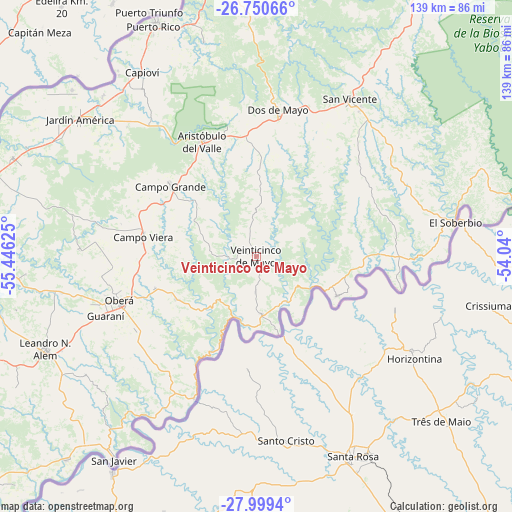
Veinticinco de Mayo GPS coordinates[2]
27° 22' 36.444" South, 54° 44' 35.232" West
| Map corner | latitude | longitude |
|---|---|---|
| Upper-left | -26.75066°, | -55.44625° |
| Center: | -27.37679°, | -54.74312° |
| Lower-right: | -27.9994°, | -54.04° |
| Map W x H: | 138.8×138.8 km | = 86.2×86.2mi |
| max Lat: | -21.94467° ⇑17.8% North |
| Veinticinco de Mayo: | -27.37679° |
| min Lat: | ⇓82.2% South -54.81084° |
| min Long | Veinticinco de | max Long |
| -72.88605° | -54.74312° | -53.64581° |
| W 98.6%⇐ | ⇒1.4% E |
Elevation
Elevation of Veinticinco de Mayo is 396 m = 1299 ft, and this is 46.7 m = 153 ft above average elevation for this country.
| Max E: |
4040 m = 13255 ft | 26.8% |
| Veinticinco de Mayo | 396 m 1299 ft | |
| Avg. | 349.3 m = 1146 ft | |
Min E: |
-2 m = -7 ft | 73.2% |
See also: Argentina elevation on elevation.city.
Geographical zone
Veinticinco de Mayo is located in South temperate zone (between Tropic of Capricorn and the Antarctic Circle). Distance of this Southern Tropic circle is 438.1 km =272.2 mi to North.| Distance of | km | miles | from Veinticinco de Mayo |
|---|---|---|---|
| Equator | 3044 | 1891.5 | to North |
| Tropic Capricorn | 438.1 | 272.2 | to North |
| Antarctic Circle | 4357.2 | 2707.4 | to South |
| South Pole | 6963 | 4326.6 | to South |


Nearby cities:
15 places around Veinticinco de Mayo: (largest is in red/bold)
• Alba Posse
22.3 km =13.9 mi,  164°
164°
• Aristóbulo del Valle
34.7 km =21.6 mi,  334°
334°
• Campo Grande
30 km =18.6 mi,  308°
308°
• Campo Ramón
28.8 km =17.9 mi,  252°
252°
• Campo Viera
31.3 km =19.4 mi,  278°
278°
• Colonia Aurora
24.1 km =15 mi,  116°
116°
• Dos de Mayo
39.8 km =24.7 mi,  8°
8°
• El Soberbio
54.5 km =33.9 mi,  80°
80°
• Florentino Ameghino
43.9 km =27.3 mi,  241°
241°
• General Alvear
42.4 km =26.3 mi,  262°
262°
• Guaraní
44.3 km =27.5 mi, 248°
• Los Helechos
38.4 km =23.9 mi, 239°
• Oberá
39.2 km =24.4 mi, 251°
• Panambí
42.1 km =26.2 mi,  203°
203°
• Ruiz de Montoya
53.2 km =33.1 mi, 325°
Sources, notices
• [Note1] Compared only with cities in Argentina existing in our database
• [Src1] Map data: © OpenStreetMap contributors (CC-BY-SA)
• [Src2] Other city data from geonames.org with taken over terms of usage.
• [Src3] Geographical zone / Annual Mean Temperature by Robert A. Rohde @ Wikipedia
