Riachuelo geodata
Riachuelo (Corrientes) is a populated place; located in Argentina in America/Argentina/Cordoba (GMT-3) time zone. With population of 3,668 people, there are 510 cities with bigger population in this country. Compared to other cities in Argentina, 78.8% of cities are located further ↓South; 79.7% of cities are located further ←West and 80.6% of cities have higher elevation than Riachuelo. Note1


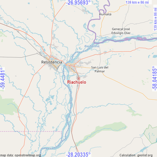
Riachuelo GPS coordinates[2]
27° 34' 54.876" South, 58° 44' 41.892" West
| Map corner | latitude | longitude |
|---|---|---|
| Upper-left | -26.95693°, | -59.4481° |
| Center: | -27.58191°, | -58.74497° |
| Lower-right: | -28.20335°, | -58.04185° |
| Map W x H: | 138.6×138.6 km | = 86.1×86.1mi |
| max Lat: | -21.94467° ⇑21.2% North |
| Riachuelo: | -27.58191° |
| min Lat: | ⇓78.8% South -54.81084° |
| min Long | Riachuelo | max Long |
| -72.88605° | -58.74497° | -53.64581° |
| W 79.7%⇐ | ⇒20.3% E |
Elevation
Elevation of Riachuelo is 57 m = 187 ft, and this is 292.3 m = 959 ft below average elevation for this country.
| Max E: |
4040 m = 13255 ft | 80.6% |
| Avg. | 349.3 m = 1146 ft | |
| Riachuelo | 57 m = 187 ft | |
Min E: |
-2 m = -7 ft | 19.4% |
See also: Argentina elevation on elevation.city.
Geographical zone
Riachuelo is located in South temperate zone (between Tropic of Capricorn and the Antarctic Circle). Distance of this Southern Tropic circle is 460.9 km =286.4 mi to North.| Distance of | km | miles | from Riachuelo |
|---|---|---|---|
| Equator | 3066.8 | 1905.6 | to North |
| Tropic Capricorn | 460.9 | 286.4 | to North |
| Antarctic Circle | 4334.4 | 2693.3 | to South |
| South Pole | 6940.2 | 4312.4 | to South |


Nearby cities:
15 places around Riachuelo: (largest is in red/bold)
• Barranqueras
22.2 km =13.8 mi,  300°
300°
• Colonia Benítez
34.2 km =21.3 mi,  324°
324°
• Corrientes
15.4 km =9.6 mi,  325°
325°
• Empedrado
41.6 km =25.8 mi,  188°
188°
• Fontana
33 km =20.5 mi, 303°
• Herlitzka
48.3 km =30 mi,  87°
87°
• Itatí
60.3 km =37.5 mi,  54°
54°
• Margarita Belén
42.1 km =26.2 mi, 327°
• Paso de la Patria
34.1 km =21.2 mi,  30°
30°
• Puerto Tirol
40.6 km =25.2 mi,  305°
305°
• Puerto Vilelas
20.6 km =12.8 mi,  291°
291°
• Ramada Paso
50.1 km =31.1 mi,  61°
61°
• Resistencia
27.1 km =16.8 mi, 299°
• San Cosme
32.8 km =20.4 mi,  44°
44°
• San Luis del Palmar
20.5 km =12.7 mi,  66°
66°
Sources, notices
• [Note1] Compared only with cities in Argentina existing in our database
• [Src1] Map data: © OpenStreetMap contributors (CC-BY-SA)
• [Src2] Other city data from geonames.org with taken over terms of usage.
• [Src3] Geographical zone / Annual Mean Temperature by Robert A. Rohde @ Wikipedia
