Empedrado geodata
Empedrado (Corrientes) is a seat of a second-order administrative division; located in Argentina in America/Argentina/Cordoba (GMT-3) time zone. In our database, there are 785 cities with bigger population. Compared to other cities in Argentina, 75.2% of cities are located further ↓South; 78.4% of cities are located further ←West and 75.7% of cities have higher elevation than Empedrado. Note1


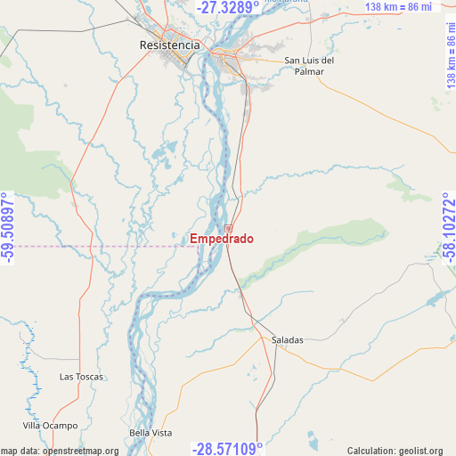
Empedrado GPS coordinates[2]
27° 57' 6.408" South, 58° 48' 21.024" West
| Map corner | latitude | longitude |
|---|---|---|
| Upper-left | -27.3289°, | -59.50897° |
| Center: | -27.95178°, | -58.80584° |
| Lower-right: | -28.57109°, | -58.10272° |
| Map W x H: | 138.1×138.1 km | = 85.8×85.8mi |
| max Lat: | -21.94467° ⇑24.8% North |
| Empedrado: | -27.95178° |
| min Lat: | ⇓75.2% South -54.81084° |
| min Long | Empedrado | max Long |
| -72.88605° | -58.80584° | -53.64581° |
| W 78.4%⇐ | ⇒21.6% E |
Elevation
Elevation of Empedrado is 68 m = 223 ft, and this is 281.3 m = 923 ft below average elevation for this country.
| Max E: |
4040 m = 13255 ft | 75.7% |
| Avg. | 349.3 m = 1146 ft | |
| Empedrado | 68 m = 223 ft | |
Min E: |
-2 m = -7 ft | 24.3% |
See also: Argentina elevation on elevation.city.
Geographical zone
Empedrado is located in South temperate zone (between Tropic of Capricorn and the Antarctic Circle). Distance of this Southern Tropic circle is 502 km =311.9 mi to North.| Distance of | km | miles | from Empedrado |
|---|---|---|---|
| Equator | 3107.9 | 1931.2 | to North |
| Tropic Capricorn | 502 | 311.9 | to North |
| Antarctic Circle | 4293.2 | 2667.7 | to South |
| South Pole | 6899.1 | 4286.9 | to South |


Nearby cities:
15 places around Empedrado: (largest is in red/bold)
• Barranqueras
53.9 km =33.5 mi,  345°
345°
• Basail
47.4 km =29.5 mi,  278°
278°
• Bella Vista
66 km =41 mi,  200°
200°
• Corrientes
53.9 km =33.5 mi,  357°
357°
• Fontana
63.1 km =39.2 mi,  340°
340°
• Herlitzka
69.1 km =42.9 mi,  51°
51°
• Las Toscas
62.9 km =39.1 mi,  224°
224°
• Mburucuyá
57.6 km =35.8 mi,  100°
100°
• Puerto Vilelas
50.4 km =31.3 mi, 344°
• Resistencia
57.4 km =35.7 mi, 342°
• Riachuelo
41.6 km =25.8 mi,  8°
8°
• Saladas
37.9 km =23.5 mi,  152°
152°
• San Lorenzo
20.5 km =12.7 mi,  169°
169°
• San Luis del Palmar
55.2 km =34.3 mi,  26°
26°
• Tacuarendí
67.9 km =42.2 mi, 220°
Sources, notices
• [Note1] Compared only with cities in Argentina existing in our database
• [Src1] Map data: © OpenStreetMap contributors (CC-BY-SA)
• [Src2] Other city data from geonames.org with taken over terms of usage.
• [Src3] Geographical zone / Annual Mean Temperature by Robert A. Rohde @ Wikipedia
