Mariano I. Loza geodata
Mariano I. Loza (Corrientes) is a populated place; located in Argentina in America/Argentina/Cordoba (GMT-3) time zone. With population of 2,015 people, there are 645 cities with bigger population in this country. Compared to other cities in Argentina, 66.7% of cities are located further ↓South; 87.8% of cities are located further ←West and 55.1% of cities have higher elevation than Mariano I. Loza. Note1


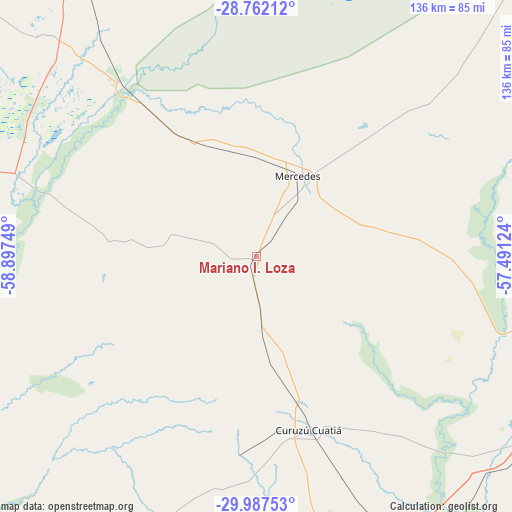
Mariano I. Loza GPS coordinates[2]
29° 22' 36.012" South, 58° 11' 39.696" West
| Map corner | latitude | longitude |
|---|---|---|
| Upper-left | -28.76212°, | -58.89749° |
| Center: | -29.37667°, | -58.19436° |
| Lower-right: | -29.98753°, | -57.49124° |
| Map W x H: | 136.3×136.3 km | = 84.7×84.7mi |
| max Lat: | -21.94467° ⇑33.3% North |
| Mariano I. Loza: | -29.37667° |
| min Lat: | ⇓66.7% South -54.81084° |
| min Long | Mariano I. Loza | max Long |
| -72.88605° | -58.19436° | -53.64581° |
| W 87.8%⇐ | ⇒12.2% E |
Elevation
Elevation of Mariano I. Loza is 122 m = 400 ft, and this is 227.3 m = 746 ft below average elevation for this country.
| Max E: |
4040 m = 13255 ft | 55.1% |
| Avg. | 349.3 m = 1146 ft | |
| Mariano I. Loza | 122 m = 400 ft | |
Min E: |
-2 m = -7 ft | 44.9% |
See also: Argentina elevation on elevation.city.
Geographical zone
Mariano I. Loza is located in South temperate zone (between Tropic of Capricorn and the Antarctic Circle). Distance of this Southern Tropic circle is 660.5 km =410.4 mi to North.| Distance of | km | miles | from Mariano I. Loza |
|---|---|---|---|
| Equator | 3266.4 | 2029.6 | to North |
| Tropic Capricorn | 660.5 | 410.4 | to North |
| Antarctic Circle | 4134.8 | 2569.2 | to South |
| South Pole | 6740.7 | 4188.5 | to South |


Nearby cities:
15 places around Mariano I. Loza: (largest is in red/bold)
• Bonpland
88.7 km =55.1 mi,  123°
123°
• Chavarría
59.6 km =37 mi,  321°
321°
• Cruz de los Milagros
99 km =61.5 mi,  307°
307°
• Curuzú Cuatiá
48.1 km =29.9 mi,  163°
163°
• Felipe Yofré
33.5 km =20.8 mi,  335°
335°
• Gobernador Juan E. Martínez
88.7 km =55.1 mi, 305°
• Libertad
82.4 km =51.2 mi,  154°
154°
• Mercedes
24.3 km =15.1 mi,  28°
28°
• Nueve de Julio
85.6 km =53.2 mi, 314°
• Pedro R. Fernández
82.8 km =51.4 mi,  327°
327°
• Perugorría
40.5 km =25.2 mi,  275°
275°
• San Roque
102.2 km =63.5 mi, 330°
• Santa Lucía
98.2 km =61 mi,  296°
296°
• Sauce
97.5 km =60.6 mi,  215°
215°
• Yataity Calle
79.9 km =49.6 mi, 299°
Sources, notices
• [Note1] Compared only with cities in Argentina existing in our database
• [Src1] Map data: © OpenStreetMap contributors (CC-BY-SA)
• [Src2] Other city data from geonames.org with taken over terms of usage.
• [Src3] Geographical zone / Annual Mean Temperature by Robert A. Rohde @ Wikipedia
