Chavarría geodata
Chavarría (Corrientes) is a populated place; located in Argentina in America/Argentina/Cordoba (GMT-3) time zone. With population of 2,337 people, there are 602 cities with bigger population in this country. Compared to other cities in Argentina, 69% of cities are located further ↓South; 82.4% of cities are located further ←West and 78.2% of cities have higher elevation than Chavarría. Note1


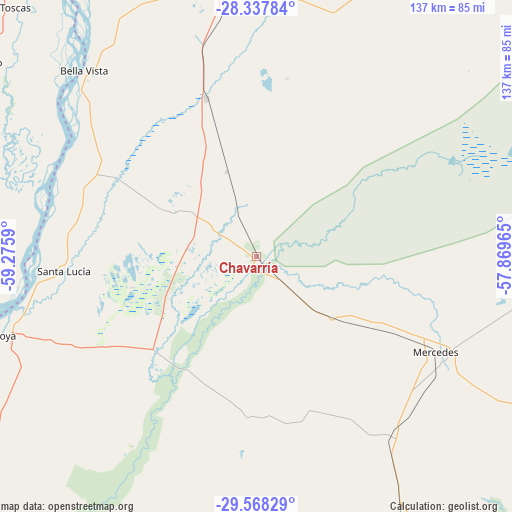
Chavarría GPS coordinates[2]
28° 57' 17.604" South, 58° 34' 21.972" West
| Map corner | latitude | longitude |
|---|---|---|
| Upper-left | -28.33784°, | -59.2759° |
| Center: | -28.95489°, | -58.57277° |
| Lower-right: | -29.56829°, | -57.86965° |
| Map W x H: | 136.8×136.8 km | = 85×85mi |
| max Lat: | -21.94467° ⇑31% North |
| Chavarría: | -28.95489° |
| min Lat: | ⇓69% South -54.81084° |
| min Long | Chavarría | max Long |
| -72.88605° | -58.57277° | -53.64581° |
| W 82.4%⇐ | ⇒17.6% E |
Elevation
Elevation of Chavarría is 64 m = 210 ft, and this is 285.3 m = 936 ft below average elevation for this country.
| Max E: |
4040 m = 13255 ft | 78.2% |
| Avg. | 349.3 m = 1146 ft | |
| Chavarría | 64 m = 210 ft | |
Min E: |
-2 m = -7 ft | 21.8% |
See also: Argentina elevation on elevation.city.
Geographical zone
Chavarría is located in South temperate zone (between Tropic of Capricorn and the Antarctic Circle). Distance of this Southern Tropic circle is 613.6 km =381.3 mi to North.| Distance of | km | miles | from Chavarría |
|---|---|---|---|
| Equator | 3219.5 | 2000.5 | to North |
| Tropic Capricorn | 613.6 | 381.3 | to North |
| Antarctic Circle | 4181.7 | 2598.4 | to South |
| South Pole | 6787.6 | 4217.6 | to South |


Nearby cities:
15 places around Chavarría: (largest is in red/bold)
• Bella Vista
67.5 km =41.9 mi,  317°
317°
• Cruz de los Milagros
44.1 km =27.4 mi,  287°
287°
• Felipe Yofré
28.1 km =17.5 mi,  125°
125°
• Gobernador Juan E. Martínez
35.7 km =22.2 mi,  277°
277°
• Goya
70.2 km =43.6 mi,  252°
252°
• Mariano I. Loza
59.6 km =37 mi,  141°
141°
• Mercedes
54.7 km =34 mi,  117°
117°
• Nueve de Julio
27.8 km =17.3 mi,  297°
297°
• Pedro R. Fernández
24.1 km =15 mi,  340°
340°
• Perugorría
43.1 km =26.8 mi,  184°
184°
• Saladas
78.1 km =48.5 mi,  356°
356°
• San Roque
44.3 km =27.5 mi, 342°
• Santa Lucía
51.7 km =32.1 mi,  265°
265°
• Santa Rosa
88.8 km =55.2 mi,  29°
29°
• Yataity Calle
33.4 km =20.8 mi,  257°
257°
Sources, notices
• [Note1] Compared only with cities in Argentina existing in our database
• [Src1] Map data: © OpenStreetMap contributors (CC-BY-SA)
• [Src2] Other city data from geonames.org with taken over terms of usage.
• [Src3] Geographical zone / Annual Mean Temperature by Robert A. Rohde @ Wikipedia
