Maipú geodata
Maipú (Buenos Aires) is a seat of a second-order administrative division; located in Argentina in America/Argentina/Buenos_Aires (GMT-3) time zone. In our database, there are 785 cities with bigger population. Compared to other cities in Argentina, 84.9% of cities are located further ↑North; 90.2% of cities are located further ←West and 95.7% of cities have higher elevation than Maipú. Note1


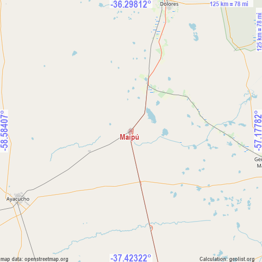
Maipú GPS coordinates[2]
36° 51' 45.864" South, 57° 52' 51.384" West
| Map corner | latitude | longitude |
|---|---|---|
| Upper-left | -36.29812°, | -58.58407° |
| Center: | -36.86274°, | -57.88094° |
| Lower-right: | -37.42322°, | -57.17782° |
| Map W x H: | 125.1×125.1 km | = 77.7×77.7mi |
| max Lat: | -21.94467° ⇑84.9% North |
| Maipú: | -36.86274° |
| min Lat: | ⇓15.1% South -54.81084° |
| min Long | Maipú | max Long |
| -72.88605° | -57.88094° | -53.64581° |
| W 90.2%⇐ | ⇒9.8% E |
Elevation
Elevation of Maipú is 16 m = 52 ft, and this is 333.3 m = 1094 ft below average elevation for this country.
| Max E: |
4040 m = 13255 ft | 95.7% |
| Avg. | 349.3 m = 1146 ft | |
| Maipú | 16 m = 52 ft | |
Min E: |
-2 m = -7 ft | 4.3% |
See also: Argentina elevation on elevation.city.
Geographical zone
Maipú is located in South temperate zone (between Tropic of Capricorn and the Antarctic Circle). Distance of this Southern Tropic circle is 1492.8 km =927.6 mi to North.| Distance of | km | miles | from Maipú |
|---|---|---|---|
| Equator | 4098.8 | 2546.9 | to North |
| Tropic Capricorn | 1492.8 | 927.6 | to North |
| Antarctic Circle | 3302.4 | 2052 | to South |
| South Pole | 5908.3 | 3671.2 | to South |


Nearby cities:
15 places around Maipú: (largest is in red/bold)
• Ayacucho
62.7 km =39 mi,  239°
239°
• Cariló
94.1 km =58.5 mi,  110°
110°
• Castelli
86.3 km =53.6 mi,  4°
4°
• Coronel Vidal
66.2 km =41.1 mi,  168°
168°
• Dolores
63.7 km =39.6 mi,  16°
16°
• General Conesa
62.5 km =38.8 mi,  52°
52°
• General Guido
25.9 km =16.1 mi, 17°
• General Juan Madariaga
67.6 km =42 mi,  102°
102°
• General Lavalle
97.8 km =60.8 mi,  58°
58°
• Mar de las Pampas
91.9 km =57.1 mi,  124°
124°
• Mar del Tuyú
111 km =69 mi,  73°
73°
• Pila
98.7 km =61.3 mi,  346°
346°
• Pinamar
94.6 km =58.8 mi, 106°
• Rauch
108 km =67.1 mi,  275°
275°
• Villa Gesell
92.1 km =57.2 mi, 118°
Sources, notices
• [Note1] Compared only with cities in Argentina existing in our database
• [Src1] Map data: © OpenStreetMap contributors (CC-BY-SA)
• [Src2] Other city data from geonames.org with taken over terms of usage.
• [Src3] Geographical zone / Annual Mean Temperature by Robert A. Rohde @ Wikipedia
