Rauch geodata
Rauch (Buenos Aires) is a seat of a second-order administrative division; located in Argentina in America/Argentina/Buenos_Aires (GMT-3) time zone. In our database, there are 785 cities with bigger population. Compared to other cities in Argentina, 84.5% of cities are located further ↑North; 75.6% of cities are located further ←West and 64.2% of cities have higher elevation than Rauch. Note1


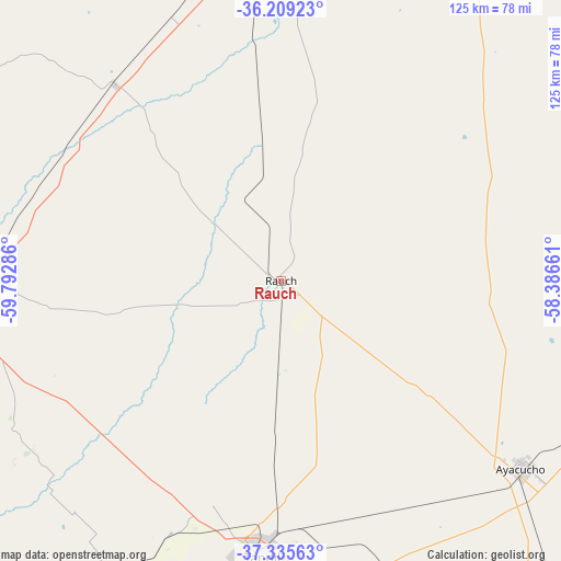
Rauch GPS coordinates[2]
36° 46' 28.2" South, 59° 5' 23.028" West
| Map corner | latitude | longitude |
|---|---|---|
| Upper-left | -36.20923°, | -59.79286° |
| Center: | -36.7745°, | -59.08973° |
| Lower-right: | -37.33563°, | -58.38661° |
| Map W x H: | 125.2×125.2 km | = 77.8×77.8mi |
| max Lat: | -21.94467° ⇑84.5% North |
| Rauch: | -36.7745° |
| min Lat: | ⇓15.5% South -54.81084° |
| min Long | Rauch | max Long |
| -72.88605° | -59.08973° | -53.64581° |
| W 75.6%⇐ | ⇒24.4% E |
Elevation
Elevation of Rauch is 95 m = 312 ft, and this is 254.3 m = 834 ft below average elevation for this country.
| Max E: |
4040 m = 13255 ft | 64.2% |
| Avg. | 349.3 m = 1146 ft | |
| Rauch | 95 m = 312 ft | |
Min E: |
-2 m = -7 ft | 35.8% |
See also: Argentina elevation on elevation.city.
Geographical zone
Rauch is located in South temperate zone (between Tropic of Capricorn and the Antarctic Circle). Distance of this Southern Tropic circle is 1483 km =921.5 mi to North.| Distance of | km | miles | from Rauch |
|---|---|---|---|
| Equator | 4088.9 | 2540.7 | to North |
| Tropic Capricorn | 1483 | 921.5 | to North |
| Antarctic Circle | 3312.2 | 2058.1 | to South |
| South Pole | 5918.1 | 3677.3 | to South |


Nearby cities:
15 places around Rauch: (largest is in red/bold)
• Ayacucho
68 km =42.3 mi,  128°
128°
• Azul
68.5 km =42.6 mi,  269°
269°
• Balcarce
140.2 km =87.1 mi,  148°
148°
• Benito Juárez
118.3 km =73.5 mi,  212°
212°
• Castelli
138 km =85.7 mi,  56°
56°
• Dolores
136 km =84.5 mi,  67°
67°
• General Alvear
117.8 km =73.2 mi,  315°
315°
• General Belgrano
123.9 km =77 mi,  25°
25°
• General Guido
116.7 km =72.5 mi,  82°
82°
• Las Flores
84.6 km =52.6 mi,  359°
359°
• Maipú
108 km =67.1 mi,  95°
95°
• Olavarría
110.5 km =68.7 mi,  263°
263°
• Pila
120.7 km =75 mi,  44°
44°
• Tandil
61 km =37.9 mi,  183°
183°
• Tapalqué
95.8 km =59.5 mi,  299°
299°
Sources, notices
• [Note1] Compared only with cities in Argentina existing in our database
• [Src1] Map data: © OpenStreetMap contributors (CC-BY-SA)
• [Src2] Other city data from geonames.org with taken over terms of usage.
• [Src3] Geographical zone / Annual Mean Temperature by Robert A. Rohde @ Wikipedia
