Ayacucho geodata
Ayacucho (Buenos Aires) is a seat of a second-order administrative division; located in Argentina in America/Argentina/Buenos_Aires (GMT-3) time zone. In our database, there are 785 cities with bigger population. Compared to other cities in Argentina, 85.9% of cities are located further ↑North; 83.9% of cities are located further ←West and 69.2% of cities have higher elevation than Ayacucho. Note1


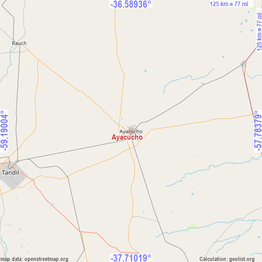
Ayacucho GPS coordinates[2]
37° 9' 6.66" South, 58° 29' 12.876" West
| Map corner | latitude | longitude |
|---|---|---|
| Upper-left | -36.58936°, | -59.19004° |
| Center: | -37.15185°, | -58.48691° |
| Lower-right: | -37.71019°, | -57.78379° |
| Map W x H: | 124.6×124.6 km | = 77.4×77.4mi |
| max Lat: | -21.94467° ⇑85.9% North |
| Ayacucho: | -37.15185° |
| min Lat: | ⇓14.1% South -54.81084° |
| min Long | Ayacucho | max Long |
| -72.88605° | -58.48691° | -53.64581° |
| W 83.9%⇐ | ⇒16.1% E |
Elevation
Elevation of Ayacucho is 81 m = 266 ft, and this is 268.3 m = 880 ft below average elevation for this country.
| Max E: |
4040 m = 13255 ft | 69.2% |
| Avg. | 349.3 m = 1146 ft | |
| Ayacucho | 81 m = 266 ft | |
Min E: |
-2 m = -7 ft | 30.8% |
See also: Argentina elevation on elevation.city.
Geographical zone
Ayacucho is located in South temperate zone (between Tropic of Capricorn and the Antarctic Circle). Distance of this Southern Tropic circle is 1525 km =947.6 mi to North.| Distance of | km | miles | from Ayacucho |
|---|---|---|---|
| Equator | 4130.9 | 2566.8 | to North |
| Tropic Capricorn | 1525 | 947.6 | to North |
| Antarctic Circle | 3270.3 | 2032.1 | to South |
| South Pole | 5876.2 | 3651.3 | to South |


Nearby cities:
15 places around Ayacucho: (largest is in red/bold)
• Azul
128.8 km =80 mi,  288°
288°
• Balcarce
79.9 km =49.6 mi,  165°
165°
• Benito Juárez
130.1 km =80.8 mi,  243°
243°
• Coronel Vidal
74.6 km =46.4 mi,  115°
115°
• Dolores
117.8 km =73.2 mi,  37°
37°
• General Conesa
125 km =77.7 mi,  55°
55°
• General Guido
84 km =52.2 mi,  47°
47°
• General Juan Madariaga
120.8 km =75.1 mi,  81°
81°
• Lobería
114.8 km =71.3 mi,  193°
193°
• Maipú
62.7 km =39 mi, 59°
• Mar de las Pampas
131.1 km =81.5 mi,  98°
98°
• Mar del Plata
125 km =77.7 mi,  139°
139°
• Pila
131.6 km =81.8 mi,  13°
13°
• Rauch
68 km =42.3 mi,  308°
308°
• Tandil
60.2 km =37.4 mi,  251°
251°
Sources, notices
• [Note1] Compared only with cities in Argentina existing in our database
• [Src1] Map data: © OpenStreetMap contributors (CC-BY-SA)
• [Src2] Other city data from geonames.org with taken over terms of usage.
• [Src3] Geographical zone / Annual Mean Temperature by Robert A. Rohde @ Wikipedia
