Campana geodata
Campana (Buenos Aires) is a seat of a second-order administrative division; located in Argentina in America/Argentina/Buenos_Aires (GMT-3) time zone. With population of 81,612 people, there are 53 cities with bigger population in this country. Compared to other cities in Argentina, 69.3% of cities are located further ↑North; 76.9% of cities are located further ←West and 95.7% of cities have higher elevation than Campana. Note1


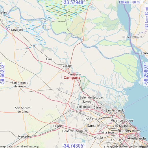
Campana GPS coordinates[2]
34° 9' 47.772" South, 58° 57' 33.084" West
| Map corner | latitude | longitude |
|---|---|---|
| Upper-left | -33.57948°, | -59.66232° |
| Center: | -34.16327°, | -58.95919° |
| Lower-right: | -34.74305°, | -58.25607° |
| Map W x H: | 129.4×129.4 km | = 80.4×80.4mi |
| max Lat: | -21.94467° ⇑69.3% North |
| Campana: | -34.16327° |
| min Lat: | ⇓30.7% South -54.81084° |
| min Long | Campana | max Long |
| -72.88605° | -58.95919° | -53.64581° |
| W 76.9%⇐ | ⇒23.1% E |
Elevation
Elevation of Campana is 16 m = 52 ft, and this is 333.3 m = 1094 ft below average elevation for this country.
| Max E: |
4040 m = 13255 ft | 95.7% |
| Avg. | 349.3 m = 1146 ft | |
| Campana | 16 m = 52 ft | |
Min E: |
-2 m = -7 ft | 4.3% |
See also: Campana elevation on elevation.city.
Geographical zone
Campana is located in South temperate zone (between Tropic of Capricorn and the Antarctic Circle). Distance of this Southern Tropic circle is 1192.7 km =741.1 mi to North.| Distance of | km | miles | from Campana |
|---|---|---|---|
| Equator | 3798.6 | 2360.3 | to North |
| Tropic Capricorn | 1192.7 | 741.1 | to North |
| Antarctic Circle | 3602.6 | 2238.6 | to South |
| South Pole | 6208.5 | 3857.8 | to South |


Nearby cities:
15 places around Campana: (largest is in red/bold)
• Belén de Escobar
25.6 km =15.9 mi,  143°
143°
• Capilla del Señor
19.4 km =12.1 mi,  222°
222°
• Don Torcuato
47.8 km =29.7 mi, 140°
• General Pacheco
43.3 km =26.9 mi, 137°
• Ingeniero Pablo Nogués
42 km =26.1 mi,  146°
146°
• José C. Paz
42.9 km =26.7 mi,  155°
155°
• Los Polvorines
44.4 km =27.6 mi, 148°
• Luján
47.2 km =29.3 mi,  196°
196°
• Pilar
33.1 km =20.6 mi,  172°
172°
• San Miguel
48 km =29.8 mi, 151°
• Santa Catalina - Dique Lujan
33.8 km =21 mi, 136°
• Tigre
45.5 km =28.3 mi,  129°
129°
• Tortuguitas
39.5 km =24.5 mi, 151°
• Villa de Mayo
46.3 km =28.8 mi, 146°
• Zárate
9.7 km =6 mi,  318°
318°
Sources, notices
• [Note1] Compared only with cities in Argentina existing in our database
• [Src1] Map data: © OpenStreetMap contributors (CC-BY-SA)
• [Src2] Other city data from geonames.org with taken over terms of usage.
• [Src3] Geographical zone / Annual Mean Temperature by Robert A. Rohde @ Wikipedia
