Chañar Ladeado geodata
Chañar Ladeado (Santa Fe) is a populated place; located in Argentina in America/Argentina/Cordoba (GMT-3) time zone. With population of 5,639 people, there are 413 cities with bigger population in this country. Compared to other cities in Argentina, 65.4% of cities are located further ↑North; 54.9% of cities are located further ←West and 57% of cities have higher elevation than Chañar Ladeado. Note1


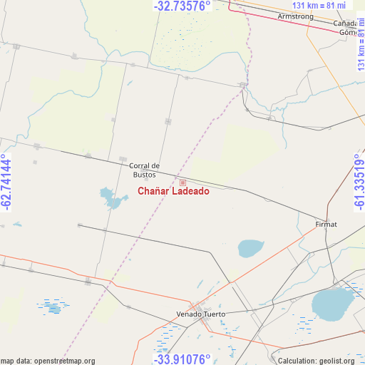
Chañar Ladeado GPS coordinates[2]
33° 19' 30.864" South, 62° 2' 17.916" West
| Map corner | latitude | longitude |
|---|---|---|
| Upper-left | -32.73576°, | -62.74144° |
| Center: | -33.32524°, | -62.03831° |
| Lower-right: | -33.91076°, | -61.33519° |
| Map W x H: | 130.6×130.6 km | = 81.2×81.2mi |
| max Lat: | -21.94467° ⇑65.4% North |
| Chañar Ladeado: | -33.32524° |
| min Lat: | ⇓34.6% South -54.81084° |
| min Long | Chañar Ladeado | max Long |
| -72.88605° | -62.03831° | -53.64581° |
| W 54.9%⇐ | ⇒45.1% E |
Elevation
Elevation of Chañar Ladeado is 116 m = 381 ft, and this is 233.3 m = 765 ft below average elevation for this country.
| Max E: |
4040 m = 13255 ft | 57% |
| Avg. | 349.3 m = 1146 ft | |
| Chañar Ladeado | 116 m = 381 ft | |
Min E: |
-2 m = -7 ft | 43% |
See also: Argentina elevation on elevation.city.
Geographical zone
Chañar Ladeado is located in South temperate zone (between Tropic of Capricorn and the Antarctic Circle). Distance of this Southern Tropic circle is 1099.5 km =683.2 mi to North.| Distance of | km | miles | from Chañar Ladeado |
|---|---|---|---|
| Equator | 3705.4 | 2302.4 | to North |
| Tropic Capricorn | 1099.5 | 683.2 | to North |
| Antarctic Circle | 3695.8 | 2296.5 | to South |
| South Pole | 6301.6 | 3915.6 | to South |


Nearby cities:
15 places around Chañar Ladeado: (largest is in red/bold)
• Alejo Ledesma
62.6 km =38.9 mi,  240°
240°
• Arias
49 km =30.4 mi,  223°
223°
• Camilo Aldao
22.6 km =14 mi,  346°
346°
• Cavanagh
32.6 km =20.3 mi, 238°
• Corral de Bustos
14.4 km =8.9 mi,  289°
289°
• Cruz Alta
41.2 km =25.6 mi,  31°
31°
• Firmat
53.6 km =33.3 mi,  106°
106°
• General Baldissera
33.6 km =20.9 mi,  312°
312°
• Guatimozín
40.1 km =24.9 mi,  247°
247°
• Inriville
46 km =28.6 mi,  337°
337°
• Isla Verde
35.2 km =21.9 mi, 285°
• Los Surgentes
37.9 km =23.5 mi,  2°
2°
• Monte Buey
59.9 km =37.2 mi,  319°
319°
• Monte Maíz
54 km =33.6 mi,  284°
284°
• Venado Tuerto
47.2 km =29.3 mi,  172°
172°
Sources, notices
• [Note1] Compared only with cities in Argentina existing in our database
• [Src1] Map data: © OpenStreetMap contributors (CC-BY-SA)
• [Src2] Other city data from geonames.org with taken over terms of usage.
• [Src3] Geographical zone / Annual Mean Temperature by Robert A. Rohde @ Wikipedia
