Firmat geodata
Firmat (Santa Fe) is a populated place; located in Argentina in America/Argentina/Cordoba (GMT-3) time zone. With population of 18,294 people, there are 203 cities with bigger population in this country. Compared to other cities in Argentina, 66.1% of cities are located further ↑North; 58% of cities are located further ←West and 59.8% of cities have higher elevation than Firmat. Note1


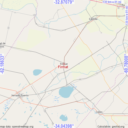
Firmat GPS coordinates[2]
33° 27' 33.732" South, 61° 28' 59.52" West
| Map corner | latitude | longitude |
|---|---|---|
| Upper-left | -32.87079°, | -62.18633° |
| Center: | -33.45937°, | -61.4832° |
| Lower-right: | -34.04398°, | -60.78008° |
| Map W x H: | 130.4×130.4 km | = 81×81mi |
| max Lat: | -21.94467° ⇑66.1% North |
| Firmat: | -33.45937° |
| min Lat: | ⇓33.9% South -54.81084° |
| min Long | Firmat | max Long |
| -72.88605° | -61.4832° | -53.64581° |
| W 58%⇐ | ⇒42% E |
Elevation
Elevation of Firmat is 109 m = 358 ft, and this is 240.3 m = 788 ft below average elevation for this country.
| Max E: |
4040 m = 13255 ft | 59.8% |
| Avg. | 349.3 m = 1146 ft | |
| Firmat | 109 m = 358 ft | |
Min E: |
-2 m = -7 ft | 40.2% |
See also: Argentina elevation on elevation.city.
Geographical zone
Firmat is located in South temperate zone (between Tropic of Capricorn and the Antarctic Circle). Distance of this Southern Tropic circle is 1114.4 km =692.5 mi to North.| Distance of | km | miles | from Firmat |
|---|---|---|---|
| Equator | 3720.3 | 2311.7 | to North |
| Tropic Capricorn | 1114.4 | 692.5 | to North |
| Antarctic Circle | 3680.8 | 2287.1 | to South |
| South Pole | 6286.7 | 3906.4 | to South |


Nearby cities:
15 places around Firmat: (largest is in red/bold)
• Armstrong
76.1 km =47.3 mi,  351°
351°
• Camilo Aldao
67.8 km =42.1 mi,  303°
303°
• Carcarañá
73.7 km =45.8 mi,  24°
24°
• Casilda
54.7 km =34 mi,  32°
32°
• Cavanagh
79.4 km =49.3 mi,  268°
268°
• Cañada de Gómez
72 km =44.7 mi,  6°
6°
• Chañar Ladeado
53.6 km =33.3 mi,  286°
286°
• Colón
60 km =37.3 mi,  143°
143°
• Corral de Bustos
68.1 km =42.3 mi, 286°
• Cruz Alta
58.5 km =36.4 mi,  328°
328°
• Los Surgentes
72.8 km =45.2 mi,  316°
316°
• Melincué
22.3 km =13.9 mi,  173°
173°
• Venado Tuerto
55.1 km =34.2 mi,  234°
234°
• Villa Cañás
61.8 km =38.4 mi,  190°
190°
• Villa Mugueta
43 km =26.7 mi,  67°
67°
Sources, notices
• [Note1] Compared only with cities in Argentina existing in our database
• [Src1] Map data: © OpenStreetMap contributors (CC-BY-SA)
• [Src2] Other city data from geonames.org with taken over terms of usage.
• [Src3] Geographical zone / Annual Mean Temperature by Robert A. Rohde @ Wikipedia
