Villa Ángela geodata
Villa Ángela (Chaco) is a seat of a second-order administrative division; located in Argentina in America/Argentina/Cordoba (GMT-3) time zone. With population of 43,511 people, there are 100 cities with bigger population in this country. Compared to other cities in Argentina, 79.2% of cities are located further ↓South; 63% of cities are located further ←West and 70.4% of cities have higher elevation than Villa Ángela. Note1


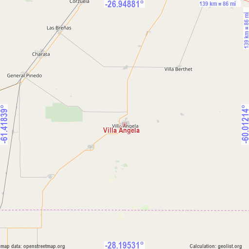
Villa Ángela GPS coordinates[2]
27° 34' 25.788" South, 60° 42' 54.936" West
| Map corner | latitude | longitude |
|---|---|---|
| Upper-left | -26.94881°, | -61.41839° |
| Center: | -27.57383°, | -60.71526° |
| Lower-right: | -28.19531°, | -60.01214° |
| Map W x H: | 138.6×138.6 km | = 86.1×86.1mi |
| max Lat: | -21.94467° ⇑20.8% North |
| Villa Ángela: | -27.57383° |
| min Lat: | ⇓79.2% South -54.81084° |
| min Long | Villa Ángela | max Long |
| -72.88605° | -60.71526° | -53.64581° |
| W 63%⇐ | ⇒37% E |
Elevation
Elevation of Villa Ángela is 79 m = 259 ft, and this is 270.3 m = 887 ft below average elevation for this country.
| Max E: |
4040 m = 13255 ft | 70.4% |
| Avg. | 349.3 m = 1146 ft | |
| Villa Ángela | 79 m = 259 ft | |
Min E: |
-2 m = -7 ft | 29.6% |
See also: Villa Ángela elevation on elevation.city.
Geographical zone
Villa Ángela is located in South temperate zone (between Tropic of Capricorn and the Antarctic Circle). Distance of this Southern Tropic circle is 460 km =285.8 mi to North.| Distance of | km | miles | from Villa Ángela |
|---|---|---|---|
| Equator | 3065.9 | 1905.1 | to North |
| Tropic Capricorn | 460 | 285.8 | to North |
| Antarctic Circle | 4335.3 | 2693.8 | to South |
| South Pole | 6941.1 | 4313 | to South |


Nearby cities:
15 places around Villa Ángela: (largest is in red/bold)
• Charadai
84.5 km =52.5 mi,  96°
96°
• Charata
61.4 km =38.2 mi,  310°
310°
• Chorotis
77.4 km =48.1 mi,  240°
240°
• Coronel Du Graty
22.9 km =14.2 mi, 238°
• Corzuela
73.4 km =45.6 mi,  339°
339°
• Gato Colorado
68.1 km =42.3 mi,  222°
222°
• General Pinedo
62.9 km =39.1 mi,  297°
297°
• Hermoso Campo
62.1 km =38.6 mi,  266°
266°
• La Clotilde
49.2 km =30.6 mi,  5°
5°
• La Tigra
53.1 km =33 mi, 13°
• Las Breñas
64.9 km =40.3 mi,  326°
326°
• Samuhú
32.4 km =20.1 mi,  79°
79°
• San Bernardo
31.8 km =19.8 mi,  0°
0°
• Santa Sylvina
50.6 km =31.4 mi, 235°
• Villa Berthet
43.3 km =26.9 mi,  43°
43°
Sources, notices
• [Note1] Compared only with cities in Argentina existing in our database
• [Src1] Map data: © OpenStreetMap contributors (CC-BY-SA)
• [Src2] Other city data from geonames.org with taken over terms of usage.
• [Src3] Geographical zone / Annual Mean Temperature by Robert A. Rohde @ Wikipedia
