Chorotis geodata
Chorotis (Chaco) is a populated place; located in Argentina in America/Argentina/Cordoba (GMT-3) time zone. With population of 1,445 people, there are 709 cities with bigger population in this country. Compared to other cities in Argentina, 75.8% of cities are located further ↓South; 58.4% of cities are located further ←West and 71.7% of cities have higher elevation than Chorotis. Note1


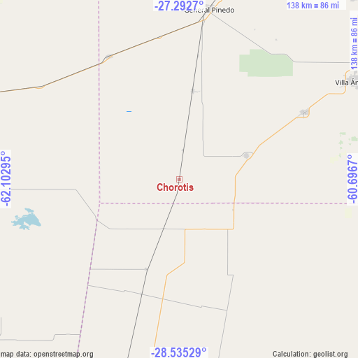
Chorotis GPS coordinates[2]
27° 54' 56.808" South, 61° 23' 59.352" West
| Map corner | latitude | longitude |
|---|---|---|
| Upper-left | -27.2927°, | -62.10295° |
| Center: | -27.91578°, | -61.39982° |
| Lower-right: | -28.53529°, | -60.6967° |
| Map W x H: | 138.2×138.2 km | = 85.9×85.9mi |
| max Lat: | -21.94467° ⇑24.2% North |
| Chorotis: | -27.91578° |
| min Lat: | ⇓75.8% South -54.81084° |
| min Long | Chorotis | max Long |
| -72.88605° | -61.39982° | -53.64581° |
| W 58.4%⇐ | ⇒41.6% E |
Elevation
Elevation of Chorotis is 76 m = 249 ft, and this is 273.3 m = 897 ft below average elevation for this country.
| Max E: |
4040 m = 13255 ft | 71.7% |
| Avg. | 349.3 m = 1146 ft | |
| Chorotis | 76 m = 249 ft | |
Min E: |
-2 m = -7 ft | 28.3% |
See also: Argentina elevation on elevation.city.
Geographical zone
Chorotis is located in South temperate zone (between Tropic of Capricorn and the Antarctic Circle). Distance of this Southern Tropic circle is 498 km =309.4 mi to North.| Distance of | km | miles | from Chorotis |
|---|---|---|---|
| Equator | 3103.9 | 1928.7 | to North |
| Tropic Capricorn | 498 | 309.4 | to North |
| Antarctic Circle | 4297.2 | 2670.2 | to South |
| South Pole | 6903.1 | 4289.4 | to South |


Nearby cities:
15 places around Chorotis: (largest is in red/bold)
• Charata
80.7 km =50.1 mi,  14°
14°
• Coronel Du Graty
54.4 km =33.8 mi,  61°
61°
• Corzuela
115.1 km =71.5 mi,  21°
21°
• Gancedo
54.5 km =33.9 mi,  330°
330°
• Gato Colorado
24 km =14.9 mi,  119°
119°
• General Pinedo
67.6 km =42 mi, 9°
• Hermoso Campo
34.6 km =21.5 mi, 9°
• La Clotilde
113.1 km =70.3 mi,  39°
39°
• Las Breñas
97.1 km =60.3 mi, 18°
• Los Juríes
92.5 km =57.5 mi,  228°
228°
• Quimilí
104.4 km =64.9 mi,  286°
286°
• Samuhú
108.5 km =67.4 mi,  66°
66°
• San Bernardo
97.3 km =60.5 mi, 44°
• Santa Sylvina
27.4 km =17 mi, 70°
• Villa Ángela
77.4 km =48.1 mi, 60°
Sources, notices
• [Note1] Compared only with cities in Argentina existing in our database
• [Src1] Map data: © OpenStreetMap contributors (CC-BY-SA)
• [Src2] Other city data from geonames.org with taken over terms of usage.
• [Src3] Geographical zone / Annual Mean Temperature by Robert A. Rohde @ Wikipedia
