Trelew geodata
Trelew (Chubut) is a populated place; located in Argentina in America/Argentina/Catamarca (GMT-3) time zone. With population of 93,442 people, there are 41 cities with bigger population in this country. Compared to other cities in Argentina, 96.6% of cities are located further ↑North; 75.5% of cities are located further →East and 96.8% of cities have higher elevation than Trelew. Note1


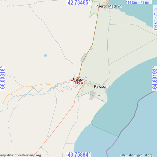
Trelew GPS coordinates[2]
43° 14' 56.22" South, 65° 18' 18.18" West
| Map corner | latitude | longitude |
|---|---|---|
| Upper-left | -42.73465°, | -66.00818° |
| Center: | -43.24895°, | -65.30505° |
| Lower-right: | -43.75894°, | -64.60193° |
| Map W x H: | 113.9×113.9 km | = 70.8×70.8mi |
| max Lat: | -21.94467° ⇑96.6% North |
| Trelew: | -43.24895° |
| min Lat: | ⇓3.4% South -54.81084° |
| min Long | Trelew | max Long |
| -72.88605° | -65.30505° | -53.64581° |
| W 24.5%⇐ | ⇒75.5% E |
Elevation
Elevation of Trelew is 14 m = 46 ft, and this is 335.3 m = 1100 ft below average elevation for this country.
| Max E: |
4040 m = 13255 ft | 96.8% |
| Avg. | 349.3 m = 1146 ft | |
| Trelew | 14 m = 46 ft | |
Min E: |
-2 m = -7 ft | 3.2% |
See also: Trelew elevation on elevation.city.
Geographical zone
Trelew is located in South temperate zone (between Tropic of Capricorn and the Antarctic Circle). Distance of this Southern Tropic circle is 2202.9 km =1368.8 mi to North.| Distance of | km | miles | from Trelew |
|---|---|---|---|
| Equator | 4808.8 | 2988 | to North |
| Tropic Capricorn | 2202.9 | 1368.8 | to North |
| Antarctic Circle | 2592.3 | 1610.8 | to South |
| South Pole | 5198.2 | 3230 | to South |


Nearby cities:
15 places around Trelew: (largest is in red/bold)
• Camarones
175.2 km =108.9 mi,  190°
190°
• Carmen de Patagones
333.3 km =207.1 mi,  35°
35°
• Comodoro Rivadavia
338.6 km =210.4 mi,  210°
210°
• Dolavón
33.1 km =20.6 mi,  258°
258°
• Gaimán
15.9 km =9.9 mi,  253°
253°
• Las Plumas
168 km =104.4 mi, 251°
• Paso de Indios
309 km =192 mi, 257°
• Puerto Madryn
57.6 km =35.8 mi,  22°
22°
• Rada Tilly
346.7 km =215.4 mi, 210°
• Rawson
17.4 km =10.8 mi,  109°
109°
• San Antonio Oeste
281.4 km =174.9 mi,  6°
6°
• Sierra Grande
182.7 km =113.5 mi,  358°
358°
• Telsen
161.1 km =100.1 mi,  304°
304°
• Valcheta
294.3 km =182.9 mi,  346°
346°
• Viedma
331.1 km =205.7 mi, 35°
Sources, notices
• [Note1] Compared only with cities in Argentina existing in our database
• [Src1] Map data: © OpenStreetMap contributors (CC-BY-SA)
• [Src2] Other city data from geonames.org with taken over terms of usage.
• [Src3] Geographical zone / Annual Mean Temperature by Robert A. Rohde @ Wikipedia
